IMAGES TAKEN NEAR TO
Cranoe Road, MARKET HARBOROUGH, LE16 7UH
Introduction
This page details the photographs taken nearby to Cranoe Road, LE16 7UH by members of the Geograph project.
The Geograph project started in 2005 with the aim of publishing, organising and preserving representative images for every square kilometre of Great Britain, Ireland and the Isle of Man.

There are currently over 7.5m images from over14,400 individuals and you can help contribute to the project by visiting https://www.geograph.org.uk
Image Map
Images are licensed for reuse under creativecommons.org/licenses/by-sa/2.0
Notes
- Clicking on the map will re-center to the selected point.
- The higher the marker number, the further away the image location is from the centre of the postcode.
Image Listing (10 Images Found)
Images are licensed for reuse under creativecommons.org/licenses/by-sa/2.0
Image
Details
Distance
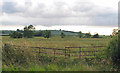
1
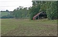
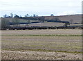
Farmland off Welham Lane, Leicestershire
Image: © Mat Fascione
Taken: 22 Sep 2007
0.06 miles
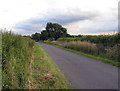
2
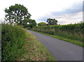
Welham Lane towards Welham
The Midshires Way long distance footpath follow this road at this point.
Image: © Andrew Tatlow
Taken: 9 Jul 2014
0.07 miles
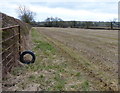
3
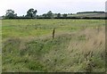
Countryside off Welham Lane
Looking towards Crossburrow Hill.
Image: © Mat Fascione
Taken: 22 Sep 2007
0.08 miles
4
Welham Lane towards Cranoe
The Midshires Way long distance footpath follow this road at this point.
Image: © Andrew Tatlow
Taken: 9 Jul 2014
0.10 miles
7
Welham Lane towards Welham
The Midshires Way long distance footpath follow this road at this point.
Image: © Andrew Tatlow
Taken: 9 Jul 2014
0.18 miles
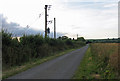
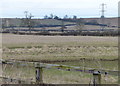
10
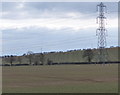
Electricity pylon and field near Welham Lodge
Image: © Mat Fascione
Taken: 31 Mar 2013
0.25 miles