IMAGES TAKEN NEAR TO
Melton Road, MARKET HARBOROUGH, LE16 7TG
Introduction
This page details the photographs taken nearby to Melton Road, LE16 7TG by members of the Geograph project.
The Geograph project started in 2005 with the aim of publishing, organising and preserving representative images for every square kilometre of Great Britain, Ireland and the Isle of Man.

There are currently over 7.5m images from over14,400 individuals and you can help contribute to the project by visiting https://www.geograph.org.uk
Image Map
Images are licensed for reuse under creativecommons.org/licenses/by-sa/2.0
Notes
- Clicking on the map will re-center to the selected point.
- The higher the marker number, the further away the image location is from the centre of the postcode.
Image Listing (17 Images Found)
Images are licensed for reuse under creativecommons.org/licenses/by-sa/2.0
Image
Details
Distance
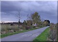
1
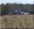
Langton View
A house along the B6047 Melton Road, viewed looking east from a lane called the Langtons.
Image: © Mat Fascione
Taken: 29 Mar 2013
0.04 miles
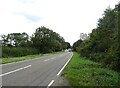
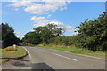
2
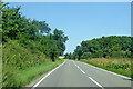
B6047 Melton Road
North from Market Harborough towards Melton Mowbray.
Image: © Robin Webster
Taken: 18 Jul 2021
0.04 miles
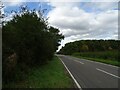
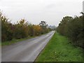
10
Melton Road near East Langton
Outside Langton Farm Shop
Image: © David Howard
Taken: 29 Jul 2019
0.18 miles