IMAGES TAKEN NEAR TO
Foxton Road, MARKET HARBOROUGH, LE16 7RY
Introduction
This page details the photographs taken nearby to Foxton Road, LE16 7RY by members of the Geograph project.
The Geograph project started in 2005 with the aim of publishing, organising and preserving representative images for every square kilometre of Great Britain, Ireland and the Isle of Man.

There are currently over 7.5m images from over14,400 individuals and you can help contribute to the project by visiting https://www.geograph.org.uk
Image Map
Images are licensed for reuse under creativecommons.org/licenses/by-sa/2.0
Notes
- Clicking on the map will re-center to the selected point.
- The higher the marker number, the further away the image location is from the centre of the postcode.
Image Listing (38 Images Found)
Images are licensed for reuse under creativecommons.org/licenses/by-sa/2.0
Image
Details
Distance
1
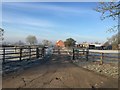
Access to stables alongside Chapel Farm
Image: © Dave Thompson
Taken: 31 Jan 2019
0.04 miles

4
Foxton Road Junction
Opposite Welland Avenue at the entrance to Chapel Farm.
Image: © Ian Rob
Taken: 17 Oct 2019
0.05 miles
6
Sign by goods entrance to HMP Gartree
Image: © Andrew Tatlow
Taken: 19 Jun 2014
0.07 miles
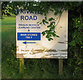
7
Sign by goods entrance to HMP Gartree
Image: © Andrew Tatlow
Taken: 19 Jun 2014
0.07 miles
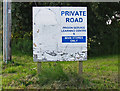
8
Private road
This is a private access road for residents of Gartree - and leads to the Stores for HMP Gartree
Image: © Dave Thompson
Taken: 31 Jan 2019
0.07 miles
9
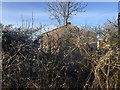
Another RAF Market Harborough building
Image: © Dave Thompson
Taken: 31 Jan 2019
0.07 miles
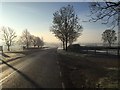
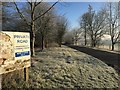
10
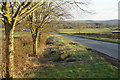
Foxton Road
Looking towards Lubenham on the road from Foxton as it drops into the upper Welland valley.
Image: © Stephen McKay
Taken: 13 Mar 2018
0.09 miles