IMAGES TAKEN NEAR TO
Clarence Street, MARKET HARBOROUGH, LE16 7NE
Introduction
This page details the photographs taken nearby to Clarence Street, LE16 7NE by members of the Geograph project.
The Geograph project started in 2005 with the aim of publishing, organising and preserving representative images for every square kilometre of Great Britain, Ireland and the Isle of Man.

There are currently over 7.5m images from over14,400 individuals and you can help contribute to the project by visiting https://www.geograph.org.uk
Image Map
Images are licensed for reuse under creativecommons.org/licenses/by-sa/2.0
Notes
- Clicking on the map will re-center to the selected point.
- The higher the marker number, the further away the image location is from the centre of the postcode.
Image Listing (220 Images Found)
Images are licensed for reuse under creativecommons.org/licenses/by-sa/2.0
Image
Details
Distance
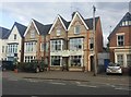
1
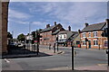
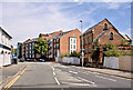
St Mary's Road
A mix of ages here. Mostly 19th Century, or very early 20th century. The 3 (and 2) storey building with the Juliette balconies and roof lights is unashamedly 21st century, and I would not be at all surprised if the chimneys were dummies. The whitewashed building has all the hallmarks of a late 19th century pub (or similar substantial business, like a timber yard), with its extension on the side having been converted to a shopfront much later. Judging by the small dormer that looks mid-wars to me.
Image: © Bob Harvey
Taken: 7 Aug 2022
0.07 miles
2
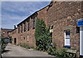
Old Harborough
A workshop converted into private houses. Bit of proper Victorian red brick among all the modern replicas
Image: © Bob Harvey
Taken: 7 Aug 2022
0.08 miles
3
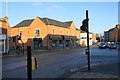
Majestic Wine
The wine retailer is situated slightly outside the town centre, in common with most of the branches.
Image: © Bill Boaden
Taken: 1 Dec 2019
0.08 miles
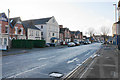
4
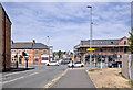
Road Junction with Traffic Lights
The end of Kettering Road. The former A6 used to run this way and turn left at this junction onto St Mary's Road.
Image: © Bob Harvey
Taken: 7 Aug 2022
0.08 miles
5
Terraced houses on St Mary's Road, Market Harborough
Image: © David Howard
Taken: 2 Jul 2019
0.08 miles
6
St Mary's Road
Heading towards the centre of Market Harborough. The road here appears to have a mixture of residential and commercial properties.
Image: © Bill Boaden
Taken: 1 Dec 2019
0.08 miles
7
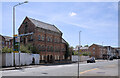
Old Factory
All that is left of the large industrial complex that was the Harborough Rubber Factory, which stretched along Rockingham Road from the junction with Kettering Road almost all the way to the railway line.
This building, alone, of that complex stands because it is a grade II listed building. Originally it was a flour mill.
For more details, see the Historic England listing at https://historicengland.org.uk/listing/the-list/list-entry/1228030?section=official-list-entry
Image: © Bob Harvey
Taken: 7 Aug 2022
0.09 miles
8
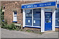
End of private road
A bright modern shopfront on a Victorian shop.
Note, too, the road name board for the houses in Image
Image: © Bob Harvey
Taken: 7 Aug 2022
0.09 miles
9
Kettering Road
Part of an inner ring road viewed from the other side of St Mary's Road.
Image: © Bill Boaden
Taken: 1 Dec 2019
0.09 miles
10
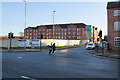
Rockingham Road
The A4304 in Market Harborough. The huge block of apartments in the distance is the LHA "retirement village" built on land that was once the trackbed and sidings of the Stamford to Rugby railway, closed in the Beeching Era.
In the foreground is the grade II listed former flour mill that was the centrepiece of the Harborough Rubber company, whose works used to fill this frontage (see Image and Image).
Image: © Bob Harvey
Taken: 7 Aug 2022
0.09 miles