IMAGES TAKEN NEAR TO
Heygate Street, MARKET HARBOROUGH, LE16 7JS
Introduction
This page details the photographs taken nearby to Heygate Street, LE16 7JS by members of the Geograph project.
The Geograph project started in 2005 with the aim of publishing, organising and preserving representative images for every square kilometre of Great Britain, Ireland and the Isle of Man.

There are currently over 7.5m images from over14,400 individuals and you can help contribute to the project by visiting https://www.geograph.org.uk
Image Map
Images are licensed for reuse under creativecommons.org/licenses/by-sa/2.0
Notes
- Clicking on the map will re-center to the selected point.
- The higher the marker number, the further away the image location is from the centre of the postcode.
Image Listing (128 Images Found)
Images are licensed for reuse under creativecommons.org/licenses/by-sa/2.0
Image
Details
Distance
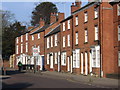
1
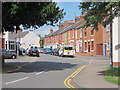
Heygate Street
Terraced houses, looking from Doddridge Road.
Image: © Oast House Archive
Taken: 2 Jul 2011
0.05 miles
8
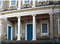
Market Harborough - church portico
This is the Congregational Church (formerly Independent Chapel). For a view of the complete frontage, please see Image
Image: © Dave Bevis
Taken: 31 Jan 2011
0.12 miles
9
Market Harborough - south end of Leicester Road
Image: © Dave Bevis
Taken: 31 Jan 2011
0.13 miles