IMAGES TAKEN NEAR TO
St. Marys Road, MARKET HARBOROUGH, LE16 7DS
Introduction
This page details the photographs taken nearby to St. Marys Road, LE16 7DS by members of the Geograph project.
The Geograph project started in 2005 with the aim of publishing, organising and preserving representative images for every square kilometre of Great Britain, Ireland and the Isle of Man.

There are currently over 7.5m images from over14,400 individuals and you can help contribute to the project by visiting https://www.geograph.org.uk
Image Map
Images are licensed for reuse under creativecommons.org/licenses/by-sa/2.0
Notes
- Clicking on the map will re-center to the selected point.
- The higher the marker number, the further away the image location is from the centre of the postcode.
Image Listing (312 Images Found)
Images are licensed for reuse under creativecommons.org/licenses/by-sa/2.0
Image
Details
Distance
1
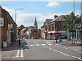
St Mary's Road
Road towards the town centre.
Image: © Oast House Archive
Taken: 2 Jul 2011
0.01 miles
2
St Mary's Road Market Harborough
Old Post office building on right.
Image: © Jim Smillie
Taken: 21 Apr 2010
0.02 miles
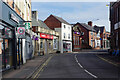
3
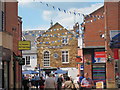
Market Harborough-Saint Mary's Road
Shops on the corner of Mill Hill Road.
Image: © Ian Rob
Taken: 3 Sep 2010
0.05 miles
4
St Mary's Road, Market Harborough
This is a stretch of the A4304 leading out of Market Harborough towards the railway station and (eventually) Corby. There is a branch of Starbucks on the left.
Image: © Stephen McKay
Taken: 13 Oct 2020
0.05 miles
5
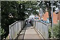
Deck of the footbridge
The deck of the bridge seen in Image, leading through to St Mary's Road.
Image: © Bob Harvey
Taken: 7 Aug 2022
0.05 miles
6

The Welland Footbridge
The bridge also seen in Image, from the other face.
Image: © Bob Harvey
Taken: 7 Aug 2022
0.05 miles
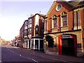
7
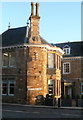
Street nameplate with road number, Market Harborough
The road number is no longer A427. There is a carving of a peacock at the base of the chimney - the building is listed (Grade II) as the Peacock Hotel, and the part in this image is an addition of 1872 to a house built c.1700.
Image: © Humphrey Bolton
Taken: 29 Jan 2018
0.06 miles
8
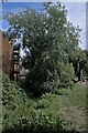
The overgrown Welland
This is the course of the River Welland, downstream of the footbridge shown in Image
Image: © Bob Harvey
Taken: 7 Aug 2022
0.06 miles
9

Downstream from the footbridge
Image: © Bob Harvey
Taken: 7 Aug 2022
0.06 miles
10
St Mary's Place
Modern pedestrianised area off St Mary's Road.
Image: © Oast House Archive
Taken: 2 Jul 2011
0.06 miles