IMAGES TAKEN NEAR TO
Metcalfe Crescent, OAKHAM, LE15 9UQ
Introduction
This page details the photographs taken nearby to Metcalfe Crescent, LE15 9UQ by members of the Geograph project.
The Geograph project started in 2005 with the aim of publishing, organising and preserving representative images for every square kilometre of Great Britain, Ireland and the Isle of Man.

There are currently over 7.5m images from over14,400 individuals and you can help contribute to the project by visiting https://www.geograph.org.uk
Image Map (Loading...)


Getting Data...Please wait
Leaflet Map data © OpenStreetMap
Images are licensed for reuse under creativecommons.org/licenses/by-sa/2.0
Notes
- Clicking on the map will re-center to the selected point.
- The higher the marker number, the further away the image location is from the centre of the postcode.
Image Listing (20 Images Found)
Images are licensed for reuse under creativecommons.org/licenses/by-sa/2.0
Image
Details
Distance
1
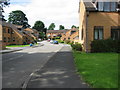
Modern Housing, Uppingham, Rutland
This recently built housing off Ayston Road, Uppingham is fairly sympathetic in building materials to the rest of the town.
Image: © Kate Jewell
Taken: 29 Aug 2005
0.14 miles
2
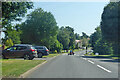
A6003 Ayston Road, Uppingham
Towards the town centre.
Image: © Robin Webster
Taken: 18 Jul 2021
0.18 miles
4
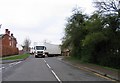
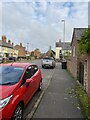
Reversal on Leicester Road
The driver was reversing into an opening that was barely 2 feet wider than his vehicle.
Image: © Andrew Tatlow
Taken: 7 Apr 2012
0.20 miles
5
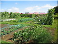
Allotment gardens on Leicester Road, Uppingham
Well tended allotments on the west side of Uppingham.
Image: © Kate Jewell
Taken: 29 Aug 2005
0.21 miles
6
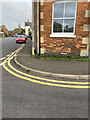
Location of OS Cut Mark - Uppingham, Number 8 Leicester Road
Image: © thejackrustles
Taken: 8 Oct 2021
0.22 miles
8
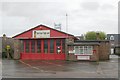
Uppingham fire station
Uppingham fire station, Ayston Road, Uppingham, Leicestershire
Image: © Kevin Hale
Taken: 5 Dec 2007
0.23 miles
9
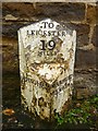
Old Milepost by the B664, North Street West,
Cast iron post by the B664 (was A47), in parish of UPPINGHAM (RUTLAND District), North Street West, in pavement, back to stone wall opposite No. 36, on South side of road. Uppingham iron casting, erected by the Leicester & Peterborough, Middle District (Uppingham) turnpike trust in the 19th century.
Inscription reads:- : UPPINGHAM : : TO / LEICESTER / 19 / MILES : : WANSFORD / 14 MILES :
Grade II listed. List Entry Number: 1252074
https://historicengland.org.uk/listing/the-list/list-entry/1252074
Milestone Society National ID: RU_UPWF00.
Image: © J Higgins
Taken: 1 Dec 2004
0.23 miles
10

Sundown on the sports field
Autumnal sunset scene at the playing fields off the Leicester Road car park.
Image: © Ian Paterson
Taken: 13 Nov 2010
0.23 miles