IMAGES TAKEN NEAR TO
Queen Street, OAKHAM, LE15 9QR
Introduction
This page details the photographs taken nearby to Queen Street, LE15 9QR by members of the Geograph project.
The Geograph project started in 2005 with the aim of publishing, organising and preserving representative images for every square kilometre of Great Britain, Ireland and the Isle of Man.

There are currently over 7.5m images from over14,400 individuals and you can help contribute to the project by visiting https://www.geograph.org.uk
Image Map
Images are licensed for reuse under creativecommons.org/licenses/by-sa/2.0
Notes
- Clicking on the map will re-center to the selected point.
- The higher the marker number, the further away the image location is from the centre of the postcode.
Image Listing (263 Images Found)
Images are licensed for reuse under creativecommons.org/licenses/by-sa/2.0
Image
Details
Distance
1
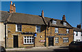
The Royal Oak
An Inn in Queen Street.
A Grade II listed building. https://historicengland.org.uk/listing/the-list/list-entry/1252075
Image: © Bob Harvey
Taken: 9 Oct 2018
0.00 miles
2
Uppingham, Royal Oak
In Queen Street; back bar with drinking areas left, front and right; pool, darts, open fire, TV. Cask ale on offer at my visit: Langton Spring Madness.
Image: © Mike Faherty
Taken: 11 May 2014
0.00 miles
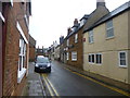
3
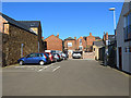
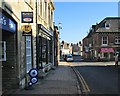
Queen Street car park, Uppingham
Parking is at a premium in the closely built-up town centre of Uppingham.
Image: © Oliver Dixon
Taken: 9 Mar 2014
0.02 miles
4
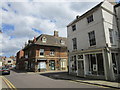
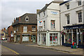
High Street, Uppingham
The building on the facing corner of Queen Street dates from about 1700 https://historicengland.org.uk/listing/the-list/list-entry/1178173
Image: © Jonathan Thacker
Taken: 30 Jun 2019
0.02 miles
5
![Uppingham buildings [29]](https://s3.geograph.org.uk/geophotos/07/14/44/7144463_3fb760b2_120x120.jpg)
Uppingham buildings [29]
Numbers 32 and 34 High Street East and number 1 Queen Street are all part of a house built circa 1700, now all with shopfronts on the ground floors. Constructed of coursed rubble stone with an ashlar front, all under a Collyweston stone slate roof. Listed, grade II, with details at: https://historicengland.org.uk/listing/the-list/list-entry/1178173
Uppingham is a market town in the county of Rutland, and received its charter in 1281. It is located near the border with Northamptonshire, approximately 17 miles east of Leicester and some 20 miles west of Peterborough. The A47 road ran through the town until a bypass was built in 1982. The town is home to Uppingham School, an independent, co-educational, fee charging school for boarders aged 13 to 18, founded in 1584.
Image: © Michael Dibb
Taken: 28 Sep 2021
0.03 miles
6
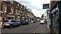
High Street, Uppingham
Looking along the eastern part of the High Street in this small Rutland town.
Image: © Stephen McKay
Taken: 20 Jul 2013
0.03 miles
7
Uppingham: the corner of Queen Street
Looking along High Street East on a February morning of bright sunlight and rich shadow.
Image: © John Sutton
Taken: 19 Feb 2013
0.03 miles
9
![Uppingham buildings [27]](https://s2.geograph.org.uk/geophotos/07/14/34/7143498_9d228c76_120x120.jpg)
Uppingham buildings [27]
Number 22 High Street East was built in the late 17th or early 18th century. Constructed of squared, coursed rubble stone under a Collyweston stone slate roof. The shopfront is early 19th century. Listed, grade II, with details at: https://historicengland.org.uk/listing/the-list/list-entry/1073188
Uppingham is a market town in the county of Rutland, and received its charter in 1281. It is located near the border with Northamptonshire, approximately 17 miles east of Leicester and some 20 miles west of Peterborough. The A47 road ran through the town until a bypass was built in 1982. The town is home to Uppingham School, an independent, co-educational, fee charging school for boarders aged 13 to 18, founded in 1584.
Image: © Michael Dibb
Taken: 28 Sep 2021
0.03 miles
10
![Uppingham buildings [24]](https://s1.geograph.org.uk/geophotos/07/14/34/7143489_ca812945_120x120.jpg)
Uppingham buildings [24]
Numbers 18 and 20 High Street East were built in the late 17th or early 18th century. Built of squared, coursed rubble stone under a tile roof. Listed, grade II, with details at: https://historicengland.org.uk/listing/the-list/list-entry/1178159
Uppingham is a market town in the county of Rutland, and received its charter in 1281. It is located near the border with Northamptonshire, approximately 17 miles east of Leicester and some 20 miles west of Peterborough. The A47 road ran through the town until a bypass was built in 1982. The town is home to Uppingham School, an independent, co-educational, fee charging school for boarders aged 13 to 18, founded in 1584.
Image: © Michael Dibb
Taken: 28 Sep 2021
0.03 miles