IMAGES TAKEN NEAR TO
High Street West, OAKHAM, LE15 9QB
Introduction
This page details the photographs taken nearby to High Street West, LE15 9QB by members of the Geograph project.
The Geograph project started in 2005 with the aim of publishing, organising and preserving representative images for every square kilometre of Great Britain, Ireland and the Isle of Man.

There are currently over 7.5m images from over14,400 individuals and you can help contribute to the project by visiting https://www.geograph.org.uk
Image Map (Loading...)


Getting Data...Please wait
Leaflet Map data © OpenStreetMap
Images are licensed for reuse under creativecommons.org/licenses/by-sa/2.0
Notes
- Clicking on the map will re-center to the selected point.
- The higher the marker number, the further away the image location is from the centre of the postcode.
Image Listing (271 Images Found)
Images are licensed for reuse under creativecommons.org/licenses/by-sa/2.0
Image
Details
Distance
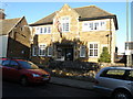
1
White Hart pub, Uppingham
Grade II listed. Listing number 1180098. Public house. C17 and later. Roughcast, probably over stone.
Image: © Andrew Abbott
Taken: 20 Aug 2017
0.00 miles
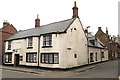
2
![Uppingham buildings [39]](https://s3.geograph.org.uk/geophotos/07/14/45/7144535_1a7a28b1_120x120.jpg)
Uppingham buildings [39]
Now a private dwelling, number 15 High Street West is the former White Hart public house. Built in the 17th century with later alterations and additions. Constructed of rendered stone under a Welsh slate roof. Listed, grade II, with details at: https://historicengland.org.uk/listing/the-list/list-entry/1180098
Uppingham is a market town in the county of Rutland, and received its charter in 1281. It is located near the border with Northamptonshire, approximately 17 miles east of Leicester and some 20 miles west of Peterborough. The A47 road ran through the town until a bypass was built in 1982. The town is home to Uppingham School, an independent, co-educational, fee charging school for boarders aged 13 to 18, founded in 1584.
Image: © Michael Dibb
Taken: 28 Sep 2021
0.00 miles
3
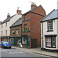
Uppingham: bookshop in High Street West
A narrow brick shop in an ironstone town.
Image: © John Sutton
Taken: 2 Jul 2013
0.01 miles
4

Barclays Bank, High Street West, Uppingham
Opposite School Lane.
Image: © Andrew Abbott
Taken: 20 Aug 2017
0.01 miles
5
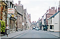
Uppingham High St., 1962
View eastward, by School Lane and beside the Central Hotel - which in 2015 seems to be no longer there. (Cf. Image). [?]
Image: © Ben Brooksbank
Taken: 4 Jun 1962
0.01 miles
6
![Uppingham School [3]](https://s1.geograph.org.uk/geophotos/07/14/56/7145601_43f779a7_120x120.jpg)
Uppingham School [3]
The buildings of Uppingham School dominate the southern side of High Street West. Seen here is the hall and classrooms built in 1923, in 16th century style, with the hall being divided horizontally around 1970. Constructed of squared, coursed rubble stone under slate roofs. Listed, grade II, with details at:
https://historicengland.org.uk/listing/the-list/list-entry/1177936
Uppingham School is an independent, co-educational, fee charging school for boarders aged 13 to 18, founded in 1584.
Uppingham is a market town in the county of Rutland, and received its charter in 1281. It is located near the border with Northamptonshire, approximately 17 miles east of Leicester and some 20 miles west of Peterborough. The A47 road ran through the town until a bypass was built in 1982.
Image: © Michael Dibb
Taken: 28 Sep 2021
0.01 miles
7
![Uppingham houses [18]](https://s0.geograph.org.uk/geophotos/07/14/56/7145608_f7c035e9_120x120.jpg)
Uppingham houses [18]
Now part of Uppingham School, number 1 School Lane is a house dated 1697. Built of coursed rubble stone, with the front of squared, coursed rubble stone, under a Welsh slate roof. Listed, grade II, with details at: https://historicengland.org.uk/listing/the-list/list-entry/1252128
Uppingham is a market town in the county of Rutland, and received its charter in 1281. It is located near the border with Northamptonshire, approximately 17 miles east of Leicester and some 20 miles west of Peterborough. The A47 road ran through the town until a bypass was built in 1982. The town is home to Uppingham School, an independent, co-educational, fee charging school for boarders aged 13 to 18, founded in 1584.
Image: © Michael Dibb
Taken: 28 Sep 2021
0.01 miles
8
![Uppingham buildings [38]](https://s0.geograph.org.uk/geophotos/07/14/45/7144532_d6472ee7_120x120.jpg)
Uppingham buildings [38]
Number 11 High Street West was built in the 18th century with 19th century alterations and additions. Constructed of coursed rubble stone under a Welsh slate roof. Listed, grade II, with details at: https://historicengland.org.uk/listing/the-list/list-entry/1295069
Uppingham is a market town in the county of Rutland, and received its charter in 1281. It is located near the border with Northamptonshire, approximately 17 miles east of Leicester and some 20 miles west of Peterborough. The A47 road ran through the town until a bypass was built in 1982. The town is home to Uppingham School, an independent, co-educational, fee charging school for boarders aged 13 to 18, founded in 1584.
Image: © Michael Dibb
Taken: 28 Sep 2021
0.01 miles
9
![Uppingham houses [9]](https://s1.geograph.org.uk/geophotos/07/14/45/7144529_b3045b77_120x120.jpg)
Uppingham houses [9]
Number 8 High Street West is a late 16th or early 17th century house with later alterations. Built of coursed rubble stone with a squared, coursed rubble stone front, all under a Collyweston stone slate roof. Listed, grade II, with details at: https://historicengland.org.uk/listing/the-list/list-entry/1295140
Uppingham is a market town in the county of Rutland, and received its charter in 1281. It is located near the border with Northamptonshire, approximately 17 miles east of Leicester and some 20 miles west of Peterborough. The A47 road ran through the town until a bypass was built in 1982. The town is home to Uppingham School, an independent, co-educational, fee charging school for boarders aged 13 to 18, founded in 1584.
Image: © Michael Dibb
Taken: 28 Sep 2021
0.01 miles