IMAGES TAKEN NEAR TO
Tokyes Close, OAKHAM, LE15 9JP
Introduction
This page details the photographs taken nearby to Tokyes Close, LE15 9JP by members of the Geograph project.
The Geograph project started in 2005 with the aim of publishing, organising and preserving representative images for every square kilometre of Great Britain, Ireland and the Isle of Man.

There are currently over 7.5m images from over14,400 individuals and you can help contribute to the project by visiting https://www.geograph.org.uk
Image Map (Loading...)


Getting Data...Please wait
Leaflet Map data © OpenStreetMap
Images are licensed for reuse under creativecommons.org/licenses/by-sa/2.0
Notes
- Clicking on the map will re-center to the selected point.
- The higher the marker number, the further away the image location is from the centre of the postcode.
Image Listing (76 Images Found)
Images are licensed for reuse under creativecommons.org/licenses/by-sa/2.0
Image
Details
Distance
1

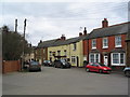
The Sun Inn, Belton-in-Rutland
Despite its shabby appearance, this one, unlike so many village pubs, is still in business.
Image: © Alan Murray-Rust
Taken: 8 May 2016
0.07 miles
2
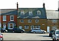
20, Main Street, Belton-in-Rutland
18th century house, coursed stone rubble with slate roof, Listed Grade II.
Image: © Alan Murray-Rust
Taken: 8 May 2016
0.08 miles
3
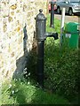
Village pump, Main Street, Belton-in-Rutland
Although a very standard model, by Lee Howl of Wolverhampton, this one is Listed Grade II.
Image: © Alan Murray-Rust
Taken: 8 May 2016
0.08 miles
4
The Sun, Belton-in-Rutland
Very proud of being in England's smallest county, the village of Belton was officially renamed Belton-in-Rutland in 1982.
Image: © Tim Heaton
Taken: 19 Mar 2006
0.09 miles
5
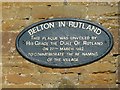
Village name plaque, Belton-in-Rutland
The name was previously simply Belton, but when the county of Rutland was made part of Leicestershire, there was another Belton in the county, and the village wished to retain its identity.
Image: © Alan Murray-Rust
Taken: 8 May 2016
0.09 miles
6
Southview Cottage, 19 Main Street, Belton-in-Rutland
Mid 17th century house with later alterations, coursed stone rubble with tile roof, Listed Grade II.
Image: © Alan Murray-Rust
Taken: 8 May 2016
0.10 miles
7
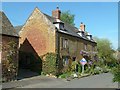
Godfrey's House, Church St, Belton-in-Rutland
Mid 17th century house, coursed stone rubble with stone-mullioned windows and Collyweston stone slate roof, Listed Grade II.
Image: © Alan Murray-Rust
Taken: 8 May 2016
0.10 miles
8
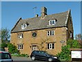
23 Main Street, Belton-in-Rutland
Late 17th century house, the nearest bay a later addition; coursed stone rubble with stone slate roof, Listed Grade II.
Image: © Alan Murray-Rust
Taken: 8 May 2016
0.10 miles
9
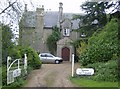
The Old Rectory B&B
A different sort of stone from other properties in this village.
Image: © Graham Horn
Taken: 24 Apr 2007
0.11 miles
10
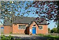
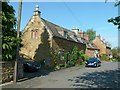
Former village school, Belton-in-Rutland
Now in use as a pre-school. There is an inscription above the doorway, 'Feed my lambs'
Image: © Alan Murray-Rust
Taken: 8 May 2016
0.11 miles