IMAGES TAKEN NEAR TO
Top Lane, OAKHAM, LE15 9ER
Introduction
This page details the photographs taken nearby to Top Lane, LE15 9ER by members of the Geograph project.
The Geograph project started in 2005 with the aim of publishing, organising and preserving representative images for every square kilometre of Great Britain, Ireland and the Isle of Man.

There are currently over 7.5m images from over14,400 individuals and you can help contribute to the project by visiting https://www.geograph.org.uk
Image Map
Images are licensed for reuse under creativecommons.org/licenses/by-sa/2.0
Notes
- Clicking on the map will re-center to the selected point.
- The higher the marker number, the further away the image location is from the centre of the postcode.
Image Listing (13 Images Found)
Images are licensed for reuse under creativecommons.org/licenses/by-sa/2.0
Image
Details
Distance
1
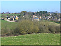
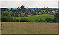
Bisbrooke village
Looking across the valley from the Uppingham to Seaton road.
The line of trees in the foreground marks the course of the old Seaton and Uppingham branch railway. It is believed that Edward Thring, the great Headmaster of Uppingham School from 1853 to 1887, raised objection to the construction of a main line railway through the town. As a result, a branch line from Seaton was not built until 1894, very late in the development of Britain's rail network. The service was very sparse - as a child growing up in Uppingham in the 1930s and 1940s, I never travelled on this line despite the paucity of alternative public transport. The line was closed to passengers in 1960, but school "Specials" continued until 1964.
Image: © Oliver Dixon
Taken: 9 Mar 2014
0.02 miles
2
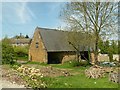
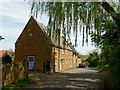
Barn on Top Lane, Bisbrooke
17th and 18th century barn, associated with the former Manor House. The left hand bay is 18th century. Listed Grade II.
Image: © Alan Murray-Rust
Taken: 8 May 2016
0.02 miles
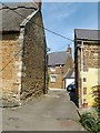
4
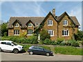
The Old Village Hall and The Old Post Office, Bisbrooke
The left hand wing was built as the village school, and is dated 1873. The initials suggest the work of Victoria Evans-Freke, Lady Carbery, of Bisbrooke Hall. The Post Office may well have been built as such, with the left hand part of the residential accommodation being the schoolmaster's house.
Image: © Alan Murray-Rust
Taken: 8 May 2016
0.05 miles
5
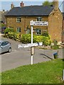
Fingerpost, Bisbrooke
A relatively modern pole, carrying traditional wooden fingers. The bus timetable case is of interest http://www.geograph.org.uk/photo/4946339
Image: © Alan Murray-Rust
Taken: 8 May 2016
0.05 miles
6
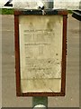
Don't try waiting for these buses
Although there is no date on the timetable display, the service is shown as being run by Barton Buses.
Barton Buses were absorbed by the Wellglade group in 1989 and ceased to trade under that name almost immediately. That means that the display is over 25 years old, and almost worthy of preservation. I have no idea when the last bus service to Bisbrooke operated.
Image: © Alan Murray-Rust
Taken: 8 May 2016
0.05 miles
8
Houses on Glaston Road, Bisbrooke
The nearer is Bilton House, mid-late 18th century, ironstone with Welsh slate roof. Beyond, No.7 is a 17th century remodelling of a cruck house of a century or more earlier. Ironstone with thatched roof. Both are Listed Grade II.
Image: © Alan Murray-Rust
Taken: 8 May 2016
0.12 miles
9
9 Glaston Road, Bisbrooke
This is the house at the end of the passage, dating from c.1800, coursed ironstone rubble with Welsh slate roof, Listed Grade II for group value.
Image: © Alan Murray-Rust
Taken: 8 May 2016
0.14 miles
10
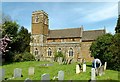
Church of St John the Baptist, Bisbrooke
Totally rebuilt in 1871 as the old church was beyond restoration. The upper stages of the tower were added in 1914, and a reproduced painting in the church shows that a spire was intended. Listed Grade II.
Image: © Alan Murray-Rust
Taken: 8 May 2016
0.16 miles