IMAGES TAKEN NEAR TO
Chapman Place, OAKHAM, LE15 9EA
Introduction
This page details the photographs taken nearby to Chapman Place, LE15 9EA by members of the Geograph project.
The Geograph project started in 2005 with the aim of publishing, organising and preserving representative images for every square kilometre of Great Britain, Ireland and the Isle of Man.

There are currently over 7.5m images from over14,400 individuals and you can help contribute to the project by visiting https://www.geograph.org.uk
Image Map (Loading...)


Getting Data...Please wait
Leaflet Map data © OpenStreetMap
Images are licensed for reuse under creativecommons.org/licenses/by-sa/2.0
Notes
- Clicking on the map will re-center to the selected point.
- The higher the marker number, the further away the image location is from the centre of the postcode.
Image Listing (5 Images Found)
Images are licensed for reuse under creativecommons.org/licenses/by-sa/2.0
Image
Details
Distance
1
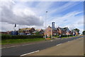
Bloor Homes, 'The Elms at Uppingham'
Housing development on Leicester Road, Uppingham. "3 & 4 bedroom homes from £263,950 to £452,950"
Image: © Tim Heaton
Taken: 24 Aug 2018
0.02 miles
2
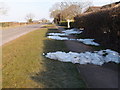
Last remnants of Winter
Snow drifts on the Leicester Road, Uppingham
Image: © Michael Trolove
Taken: 7 Apr 2013
0.04 miles
4
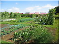
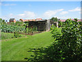
Allotment gardens on Leicester Road, Uppingham
Well tended allotments on the west side of Uppingham.
Image: © Kate Jewell
Taken: 29 Aug 2005
0.14 miles