IMAGES TAKEN NEAR TO
Wing Road, OAKHAM, LE15 9BY
Introduction
This page details the photographs taken nearby to Wing Road, LE15 9BY by members of the Geograph project.
The Geograph project started in 2005 with the aim of publishing, organising and preserving representative images for every square kilometre of Great Britain, Ireland and the Isle of Man.

There are currently over 7.5m images from over14,400 individuals and you can help contribute to the project by visiting https://www.geograph.org.uk
Image Map (Loading...)


Getting Data...Please wait
Leaflet Map data © OpenStreetMap
Images are licensed for reuse under creativecommons.org/licenses/by-sa/2.0
Notes
- Clicking on the map will re-center to the selected point.
- The higher the marker number, the further away the image location is from the centre of the postcode.
Image Listing (62 Images Found)
Images are licensed for reuse under creativecommons.org/licenses/by-sa/2.0
Image
Details
Distance
1
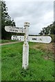
Old Direction Sign - Signpost by Wing Road, Glaston Parish
Octagonal finial - 3 arms; Rutland County Council concrete by the UC road, in parish of Glaston (Rutland District), Wing Road, on grass triangle.
Surveyed
Milestone Society National ID: RU_SK8900
Image: © Milestone Society
Taken: Unknown
0.03 miles
2
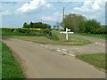
Road junction, Wing Road, Glaston
Complete with typical Rutland fingerpost http://www.geograph.org.uk/photo/4946598
Image: © Alan Murray-Rust
Taken: 8 May 2016
0.04 miles
3
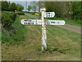
Fingerpost, Wing Road, Glaston
Standard Rutland County Council concrete style.
Image: © Alan Murray-Rust
Taken: 8 May 2016
0.04 miles
5
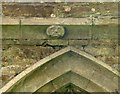
Church of St Andrew, Glaston
Grotesque, north aisle string course. There are a series of these faces along the string course.
Image: © Alan Murray-Rust
Taken: 8 May 2016
0.09 miles
6
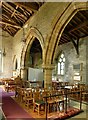
Church of St Andrew, Glaston
The north aisle arcade, looking west. The pier and respond, with waterleaf capitals, are from around 1200, Transitional, the arches being replaced later, in the 14th century. The small arch at the far end is the 14th century extension of the church to the west.
Image: © Alan Murray-Rust
Taken: 8 May 2016
0.10 miles
7
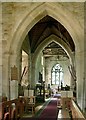
Church of St Andrew, Glaston
Looking from the chancel through the tower base to the nave. The bellringers have to stand in the middle of the church when ringing. The chancel arch was rebuilt in the 18th century.
Image: © Alan Murray-Rust
Taken: 8 May 2016
0.10 miles
8
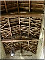
Church of St Andrew, Glaston
The nave roof looking west. The far end appears to have been restored first, the tie beam inscribed 1744, the other two beams, of which one can be seen here, are dated 1750.
Image: © Alan Murray-Rust
Taken: 8 May 2016
0.10 miles
9
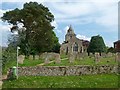
Church of St Andrew, Glaston
The view from Wing Road.
Image: © Alan Murray-Rust
Taken: 8 May 2016
0.10 miles
10
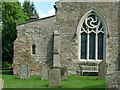
Church of St Andrew, Glaston
The west end. The main west window was inserted during the 1860s restoration and is said to have been carved by Lord Carbery who is known to have been a talented amateur stone carver. The small lancet in the aisle is 12th century and pre-dates the extension of the aisle in the 14th, and was probably moved from the aisle. It was blocked to allow a monument to be sited on the inside wall.
Image: © Alan Murray-Rust
Taken: 8 May 2016
0.10 miles