IMAGES TAKEN NEAR TO
Main Road, OAKHAM, LE15 9BS
Introduction
This page details the photographs taken nearby to Main Road, LE15 9BS by members of the Geograph project.
The Geograph project started in 2005 with the aim of publishing, organising and preserving representative images for every square kilometre of Great Britain, Ireland and the Isle of Man.

There are currently over 7.5m images from over14,400 individuals and you can help contribute to the project by visiting https://www.geograph.org.uk
Image Map (Loading...)


Getting Data...Please wait
Leaflet Map data © OpenStreetMap
Images are licensed for reuse under creativecommons.org/licenses/by-sa/2.0
Notes
- Clicking on the map will re-center to the selected point.
- The higher the marker number, the further away the image location is from the centre of the postcode.
Image Listing (52 Images Found)
Images are licensed for reuse under creativecommons.org/licenses/by-sa/2.0
Image
Details
Distance
1
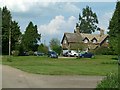
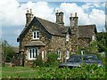
Park Cottages, Glaston (Nos. 3-6)
One of a group of four similar buildings built for the Bisbrooke Hall estate. One is inscribed VEF 1868, the initials probably referring to Victoria Evans-Freke, Lady Carbery at the time. Limestone and ironstone dressed in rustic style, with Collyweston stone slate roof, Listed Grade II.
Image: © Alan Murray-Rust
Taken: 8 May 2016
0.01 miles
2
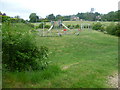
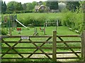
Playground at Glaston
Seen from Wing Road, this is the playground for Glaston village.
Image: © Marathon
Taken: 26 May 2011
0.05 miles
3
Park Cottages, Glaston (Nos. 9 & 10)
One of a group of four similar buildings built for the Bisbrooke Hall estate. There is a datestone inscribed VEF 1868, the initials probably referring to Victoria Evans-Freke, Lady Carbery at the time. Limestone and ironstone dressed in rustic style, with Collyweston stone slate roof, Listed Grade II.
Image: © Alan Murray-Rust
Taken: 8 May 2016
0.05 miles
4
Children's playground, Glaston
No Dogs Please, but there is a horse or two. The field beyond is the site of an Anglo-Saxon burial ground, discovered during sand quarrying.
Image: © Alan Murray-Rust
Taken: 8 May 2016
0.08 miles
6
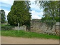
Churchyard entrance and wall,
The high part of the wall separates the churchyard from the old rectory grounds and dates from around 1700. Listed Grade II for group value.
Image: © Alan Murray-Rust
Taken: 8 May 2016
0.10 miles
7
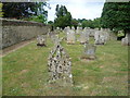
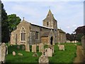
Lichen-encrusted gravestones in Glaston Churchyard
The churchyard of St Andrew has been tidied up but fortunately many of the gravestones have been left.
Image: © Marathon
Taken: 26 May 2011
0.11 miles
8
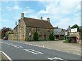
Glaston Grange Farmhouse
Early 18th century house, dated 1706, with rear wing from c.1800. The distinctive feature is the banding of lighter stone. Coursed stone rubble with ashlar dressings and modern tiled roof, Listed Grade II.
Image: © Alan Murray-Rust
Taken: 8 May 2016
0.11 miles