IMAGES TAKEN NEAR TO
Lodge Lane, OAKHAM, LE15 8SS
Introduction
This page details the photographs taken nearby to Lodge Lane, LE15 8SS by members of the Geograph project.
The Geograph project started in 2005 with the aim of publishing, organising and preserving representative images for every square kilometre of Great Britain, Ireland and the Isle of Man.

There are currently over 7.5m images from over14,400 individuals and you can help contribute to the project by visiting https://www.geograph.org.uk
Image Map (Loading...)


Getting Data...Please wait
Leaflet Map data © OpenStreetMap
Images are licensed for reuse under creativecommons.org/licenses/by-sa/2.0
Notes
- Clicking on the map will re-center to the selected point.
- The higher the marker number, the further away the image location is from the centre of the postcode.
Image Listing (40 Images Found)
Images are licensed for reuse under creativecommons.org/licenses/by-sa/2.0
Image
Details
Distance
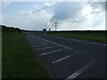
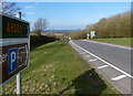
1
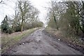
The old main road near Manton Lodge
This road terminates here now a new road links the railway bridge at Manton to Preston
Image: © Terry Butcher
Taken: 10 Mar 2006
0.07 miles
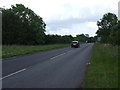
2
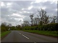
Telecoms mast entering Manton
The road continues to the south shore of Rutland water.
Image: © Steve Fareham
Taken: 28 Apr 2009
0.09 miles
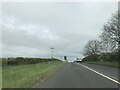
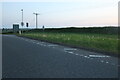
10

Bus shelter along Lyndon Road in Manton
Image: © Mat Fascione
Taken: 15 Mar 2014
0.15 miles