IMAGES TAKEN NEAR TO
Main Street, OAKHAM, LE15 8PA
Introduction
This page details the photographs taken nearby to Main Street, LE15 8PA by members of the Geograph project.
The Geograph project started in 2005 with the aim of publishing, organising and preserving representative images for every square kilometre of Great Britain, Ireland and the Isle of Man.

There are currently over 7.5m images from over14,400 individuals and you can help contribute to the project by visiting https://www.geograph.org.uk
Image Map (Loading...)


Getting Data...Please wait
Leaflet Map data © OpenStreetMap
Images are licensed for reuse under creativecommons.org/licenses/by-sa/2.0
Notes
- Clicking on the map will re-center to the selected point.
- The higher the marker number, the further away the image location is from the centre of the postcode.
Image Listing (149 Images Found)
Images are licensed for reuse under creativecommons.org/licenses/by-sa/2.0
Image
Details
Distance
1
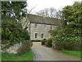
Copper Beech, Wakerley
Formerly the rectory, mainly mid to late 18th century and 19th century, probably with earlier origins, coursed stone rubble with Collyweston stone slate roof, Listed Grade II.
Image: © Alan Murray-Rust
Taken: 4 Apr 2016
0.00 miles
2
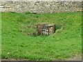
Village well, Wakerley
Until the advent of mains water, this would have been the main supply for the village.
Image: © Alan Murray-Rust
Taken: 4 Apr 2016
0.03 miles
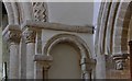
3

Wakerley: St. John the Baptist church: The famous Norman chancel arch capital 2
Showing the smaller one to the left depicting intertwined foliage.
Image: © Michael Garlick
Taken: 27 Oct 2015
0.09 miles
4
Wakerley: St. John the Baptist church: The Norman chancel and blind arches
Image: © Michael Garlick
Taken: 27 Oct 2015
0.09 miles
5
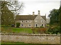
The Manor House, Wakerley
The oldest part of the house, to the right, dates from 1769. The wing extending left is an early 19th century addition. Squared coursed limestone with Collyweston stone slate roof, Listed Grade II.
Image: © Alan Murray-Rust
Taken: 4 Apr 2016
0.09 miles
6
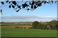
Wakerley to Morcott
A view from Wakerley churchyard, on the Northamptonshire side of the Welland Valley, towards the south-facing slopes on the Rutland side, with Morcott Windmill on the skyline in the centre, two miles or so away.
Image: © John Sutton
Taken: 25 Oct 2014
0.11 miles
8
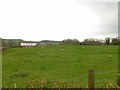
Site of the old Manor House and gardens, Wakerley
Originally in the ownership of the Cecil family (of Burghley House), it seems that the house was unoccupied before the end of the 17th century. The date or building is unrecorded but could be either late 16th or early 17th century. The substantial remaining earthworks represent not only the ruins of the house but of an extensive garden layout, a rare survivor of the period. A detailed plan of the layout can be found on the British History Online website https://www.british-history.ac.uk/rchme/northants/vol1/pp103-105
Image: © Alan Murray-Rust
Taken: 4 Apr 2016
0.13 miles
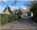
9
5 Main Street, Wakerley
Early 18th century small thatched cottage, Listed Grade II.
Image: © Alan Murray-Rust
Taken: 4 Apr 2016
0.13 miles
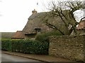
10
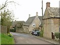
Main Street, Wakerley
The eastern end. There is a bench mark http://www.geograph.org.uk/photo/4899675 on the near corner of the cottage on the right.
Image: © Alan Murray-Rust
Taken: 4 Apr 2016
0.15 miles