IMAGES TAKEN NEAR TO
Old School Close, OAKHAM, LE15 8LG
Introduction
This page details the photographs taken nearby to Old School Close, LE15 8LG by members of the Geograph project.
The Geograph project started in 2005 with the aim of publishing, organising and preserving representative images for every square kilometre of Great Britain, Ireland and the Isle of Man.

There are currently over 7.5m images from over14,400 individuals and you can help contribute to the project by visiting https://www.geograph.org.uk
Image Map (Loading...)


Getting Data...Please wait
Leaflet Map data © OpenStreetMap
Images are licensed for reuse under creativecommons.org/licenses/by-sa/2.0
Notes
- Clicking on the map will re-center to the selected point.
- The higher the marker number, the further away the image location is from the centre of the postcode.
Image Listing (169 Images Found)
Images are licensed for reuse under creativecommons.org/licenses/by-sa/2.0
Image
Details
Distance
1
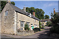
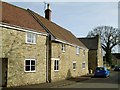
1 to 3 Old School Close, North Luffenham
3 Grade II Listed cottages of about 1800.
Image: © Jo and Steve Turner
Taken: 28 Aug 2017
0.00 miles
2
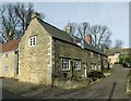
Cottages, Old School Close
A group of 3 cottages from around 1800, coursed stone rubble with later Welsh slate roof, Listed Grade II.
Image: © Alan Murray-Rust
Taken: 29 Feb 2016
0.01 miles
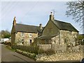
3
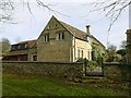
The Old School House, North Luffenham
Built in 1858 as the village school under the auspices of Baron Aveland (C H Heathcote), supposedly incorporating stone from the old Luffenham Hall. coursed stone rubble with ashlar dressings and Collyweston stone slate roof, Listed Grade II for group value.
Image: © Alan Murray-Rust
Taken: 29 Feb 2016
0.01 miles
4
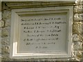
Commemorative stone, The Old School House, North Luffenham
See http://www.geograph.org.uk/photo/4849371 for location.
Image: © Alan Murray-Rust
Taken: 29 Feb 2016
0.01 miles
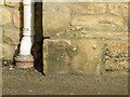
5
11 Church Street, North Luffenham
There is a bench mark http://www.geograph.org.uk/photo/4849362 on the corner adjacent to the down-pipe.
Image: © Alan Murray-Rust
Taken: 29 Feb 2016
0.02 miles
6
Sycamore Cottage, Church St, North Luffenham
Originally a pair of cottages of around 1800, now combined into one house. coursed stone rubble with Welsh slate roof, Listed Grade II.
Image: © Alan Murray-Rust
Taken: 29 Feb 2016
0.02 miles
7
Bench mark, 11 Church St, North Luffenham
See http://www.geograph.org.uk/photo/4849364 for location.
Image: © Alan Murray-Rust
Taken: 29 Feb 2016
0.02 miles
8
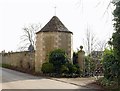
Gazebo and garden wall, Luffenham Hall
18th century, forming part of the perimeter of the Hall gardens. coursed stone rubble with ashlar dressings and Collyweston stone slate roof. Listed Grade II.
Image: © Alan Murray-Rust
Taken: 29 Feb 2016
0.03 miles
9
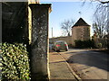
Gate pier and Gazebo, North Luffenham
The gate pier is one of two, probably ex situ, which belonged to the Old Hall which was demolished in 1806 https://historicengland.org.uk/listing/the-list/list-entry/1177916?section=official-list-entry The Gazebo dates to the eighteenth century https://historicengland.org.uk/listing/the-list/list-entry/1177916?section=official-list-entry
Image: © Jonathan Thacker
Taken: 2 Jan 2023
0.03 miles
10
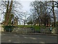
The Oval Recreation Ground, North Luffenham
The village is fortunate to have this extensive open space in its centre, large enough to accommodate both cricket ground and football pitch.
Image: © Alan Murray-Rust
Taken: 29 Feb 2016
0.03 miles