IMAGES TAKEN NEAR TO
St. Marys Close, OAKHAM, LE15 8HF
Introduction
This page details the photographs taken nearby to St. Marys Close, LE15 8HF by members of the Geograph project.
The Geograph project started in 2005 with the aim of publishing, organising and preserving representative images for every square kilometre of Great Britain, Ireland and the Isle of Man.

There are currently over 7.5m images from over14,400 individuals and you can help contribute to the project by visiting https://www.geograph.org.uk
Image Map (Loading...)


Getting Data...Please wait
Leaflet Map data © OpenStreetMap
Images are licensed for reuse under creativecommons.org/licenses/by-sa/2.0
Notes
- Clicking on the map will re-center to the selected point.
- The higher the marker number, the further away the image location is from the centre of the postcode.
Image Listing (133 Images Found)
Images are licensed for reuse under creativecommons.org/licenses/by-sa/2.0
Image
Details
Distance
1

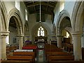
Chancel, St Mary's church
This lovely little church has a complex layout and history. The chancel appears to be a C19th re-creation.
Image: © Simon Huguet
Taken: 21 Aug 2008
0.06 miles
2
Waterleaf respond
Late 12th century chancel arch respond in St.Mary's church
Image: © Richard Croft
Taken: 16 Feb 2009
0.06 miles
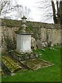
3
St Mary's, Edith Weston
Memorial in the churchyard.
Image: © Ben Keating
Taken: 1 Apr 2013
0.06 miles
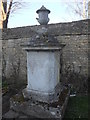
4
Church of St Mary, Edith Weston
Monument to Richard Lucas, d.1812. The Lucas family held the Manor from 1742. Listed Grade II.
Image: © Alan Murray-Rust
Taken: 22 Feb 2016
0.06 miles
5
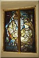
Dan Becker window
Marvellous stained glass window in St.Mary's church, what appears to be Jesus and disciples fishing on the Sea of Galilee, however the half-submerged Normanton church http://www.geograph.org.uk/photo/1035878 is in the background, suggesting it's Rutland Water.
Given in Loving Memory of Dan Becker 1903-1989 by his wife Elsie
Image: © Richard Croft
Taken: 16 Feb 2009
0.06 miles
6
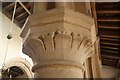
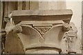
Waterleaf capital
Late 12th century Norman waterleaf capital in St.Mary's church
Image: © Richard Croft
Taken: 16 Feb 2009
0.06 miles
7

Wanna visit the dark side
Public footpath along Normanton Road just leaving Edith Weston.
Image: © Ben Keating
Taken: 1 Apr 2013
0.07 miles
8
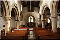
St.Mary's nave
Looking east with Norman arcades and early Gothic chancel arch c1200
Image: © Richard Croft
Taken: 16 Feb 2009
0.07 miles
9
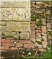
Bench mark, St Mary's Church, Edith Weston
See http://www.geograph.org.uk/photo/4839404 for location.
Image: © Alan Murray-Rust
Taken: 22 Feb 2016
0.07 miles
10
Church of St Mary, Edith Weston
The nave looking east.
Image: © Alan Murray-Rust
Taken: 22 Feb 2016
0.07 miles