IMAGES TAKEN NEAR TO
Manton Road, OAKHAM, LE15 8HB
Introduction
This page details the photographs taken nearby to Manton Road, LE15 8HB by members of the Geograph project.
The Geograph project started in 2005 with the aim of publishing, organising and preserving representative images for every square kilometre of Great Britain, Ireland and the Isle of Man.

There are currently over 7.5m images from over14,400 individuals and you can help contribute to the project by visiting https://www.geograph.org.uk
Image Map (Loading...)


Getting Data...Please wait
Leaflet Map data © OpenStreetMap
Images are licensed for reuse under creativecommons.org/licenses/by-sa/2.0
Notes
- Clicking on the map will re-center to the selected point.
- The higher the marker number, the further away the image location is from the centre of the postcode.
Image Listing (5 Images Found)
Images are licensed for reuse under creativecommons.org/licenses/by-sa/2.0
Image
Details
Distance
1

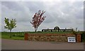
Entrance on the Edith Weston road
The Rutland Water Golf Course shares this entrance with Rutland Water Pick-Your-Own.
Image: © Kate Jewell
Taken: 27 Jul 2006
0.07 miles
2
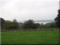
Asparagus for sale at Rutland Water Golf Club
Image: © Steve Fareham
Taken: 28 Apr 2009
0.22 miles
4
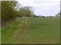
Bridleway near Lyndon
Leading down to the shore of Rutland Water.
Image: © Alan Murray-Rust
Taken: 29 Feb 2016
0.24 miles