IMAGES TAKEN NEAR TO
Wakerley Road, OAKHAM, LE15 8EP
Introduction
This page details the photographs taken nearby to Wakerley Road, LE15 8EP by members of the Geograph project.
The Geograph project started in 2005 with the aim of publishing, organising and preserving representative images for every square kilometre of Great Britain, Ireland and the Isle of Man.

There are currently over 7.5m images from over14,400 individuals and you can help contribute to the project by visiting https://www.geograph.org.uk
Image Map (Loading...)


Getting Data...Please wait
Leaflet Map data © OpenStreetMap
Images are licensed for reuse under creativecommons.org/licenses/by-sa/2.0
Notes
- Clicking on the map will re-center to the selected point.
- The higher the marker number, the further away the image location is from the centre of the postcode.
Image Listing (88 Images Found)
Images are licensed for reuse under creativecommons.org/licenses/by-sa/2.0
Image
Details
Distance
1
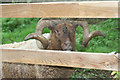
Ram
One of a pair of fine rams who live in a small field behind the village shop.
Image: © Tom Presland
Taken: 8 Sep 2010
0.04 miles
2
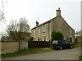
Brookleigh, Kings Lane, Barrowden
Early 19th century house, coursed stone rubble with ashlar dressings and Welsh slate roof, Listed Grade II.
Image: © Alan Murray-Rust
Taken: 11 Apr 2016
0.07 miles
3
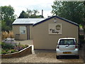
Community Shop
There are very few shops in this part of the World, so local people opened and run this community shop. It also has a cafe offering internet access.
Image: © Tom Presland
Taken: 7 Sep 2010
0.07 miles
4
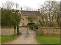
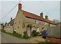
Mill House, Wakerley Road, Barrowden
A large house, dated 1630 with 20th century additions. coursed stone rubble with stone-mullioned windows and Collyweston stone slate roof, Listed Grade II. Formerly the Windmill Inn.
Image: © Alan Murray-Rust
Taken: 4 Apr 2016
0.08 miles
5
8 and 6 Wheel Lane, Barrowden
No.8 (nearer) is 18th century, coursed stone rubble with later tiled roof, Listed Grade II. No.6 beyond is early 19th century, with pantile roof, Listed Grade II for group value.
Image: © Alan Murray-Rust
Taken: 11 Apr 2016
0.09 miles
6
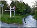
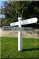
Fingerpost, Wakerley Road, Barrowden
Standard Rutland County Council concrete style, with extra arm added for the local shop. The left hand arm is not pointing along the A47, but towards it, a couple of miles away.
Image: © Alan Murray-Rust
Taken: 4 Apr 2016
0.10 miles
7
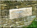
Jubilee stone
The inscription is fully informative.
Image: © Alan Murray-Rust
Taken: 4 Apr 2016
0.10 miles
8
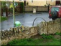
Stile into the recreation ground
An ingenious use of a cast-off wheel rim to form a handrail.
Image: © Alan Murray-Rust
Taken: 4 Apr 2016
0.10 miles
9
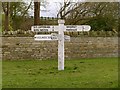
Old Direction Sign - Signpost by Wakerley Road, Barrowden Parish
Octagonal finial - 5 arms; Rutland County Council concrete by the UC road, in parish of Barrowden (Rutland District), junction of Main Street and Wakerley Road, on wide grass verge.
Surveyed
Milestone Society National ID: RU_SK9500.
Image: © Milestone Society
Taken: Unknown
0.10 miles
10
Fingerpost, Main Street/Wakerley Road, Barrowden
Standard Rutland County Council concrete style, with extra arm added for the local shop.
Image: © Alan Murray-Rust
Taken: 4 Apr 2016
0.10 miles