IMAGES TAKEN NEAR TO
Oakham Road, OAKHAM, LE15 8DG
Introduction
This page details the photographs taken nearby to Oakham Road, LE15 8DG by members of the Geograph project.
The Geograph project started in 2005 with the aim of publishing, organising and preserving representative images for every square kilometre of Great Britain, Ireland and the Isle of Man.

There are currently over 7.5m images from over14,400 individuals and you can help contribute to the project by visiting https://www.geograph.org.uk
Image Map (Loading...)


Getting Data...Please wait
Leaflet Map data © OpenStreetMap
Images are licensed for reuse under creativecommons.org/licenses/by-sa/2.0
Notes
- Clicking on the map will re-center to the selected point.
- The higher the marker number, the further away the image location is from the centre of the postcode.
Image Listing (26 Images Found)
Images are licensed for reuse under creativecommons.org/licenses/by-sa/2.0
Image
Details
Distance
1
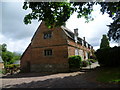
Brooke Priory
Brooke Priory was a small Augustinian house founded about 1150. Only earthworks now remain of the priory. The priory site was bought by the Noels in 1549 who built a large house, but again little remains. The present Brooke Priory seems to date from the late 17th century.
Image: © Marathon
Taken: 26 May 2011
0.01 miles
3
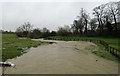
The River Gwash is awash towards Rutland Water
Image: © Andrew Tatlow
Taken: 9 Mar 2016
0.05 miles
4
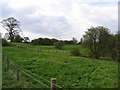
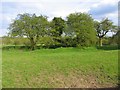
Earthworks
The OS map shows ancient earthworks just here.
Image: © Andrew Tatlow
Taken: 28 Apr 2006
0.05 miles
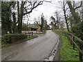
6
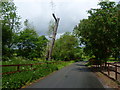
Looking down the lane opposite Brooke Priory
The heavy rain of the morning had now passed away and the first patch of blue sky was appearing. This view looks down the lane from outside Brooke Priory.
Image: © Marathon
Taken: 26 May 2011
0.05 miles
7
Brooke Priory
The OS map shows extensive earthworks adjacent to Brooke Priory Farm.
Image: © Andrew Tatlow
Taken: 28 Apr 2006
0.06 miles
8

River Gwash goes under Brooke Road downstream side
The water was at the top of the arch.
Image: © Andrew Tatlow
Taken: 9 Mar 2016
0.07 miles
9
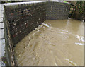
River Gwash goes under Brooke Road upstream side
The water was at the top of the arch.
Image: © Andrew Tatlow
Taken: 9 Mar 2016
0.07 miles
10
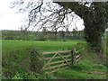
After the rain
The heavy rain of the morning had now passed away and the first patch of blue sky was appearing. This view looks along the footpath opposite Brooke Priory.
Image: © Marathon
Taken: 26 May 2011
0.07 miles