IMAGES TAKEN NEAR TO
The Brooks, OAKHAM, LE15 8BS
Introduction
This page details the photographs taken nearby to The Brooks, LE15 8BS by members of the Geograph project.
The Geograph project started in 2005 with the aim of publishing, organising and preserving representative images for every square kilometre of Great Britain, Ireland and the Isle of Man.

There are currently over 7.5m images from over14,400 individuals and you can help contribute to the project by visiting https://www.geograph.org.uk
Image Map (Loading...)


Getting Data...Please wait
Leaflet Map data © OpenStreetMap
Images are licensed for reuse under creativecommons.org/licenses/by-sa/2.0
Notes
- Clicking on the map will re-center to the selected point.
- The higher the marker number, the further away the image location is from the centre of the postcode.
Image Listing (11 Images Found)
Images are licensed for reuse under creativecommons.org/licenses/by-sa/2.0
Image
Details
Distance
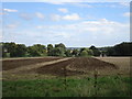
2
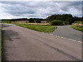
Road junction and grass triangle
Grass triangle on road junction just out of Exton.
Image: © Michael Trolove
Taken: 4 Sep 2016
0.14 miles
3
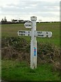
Fingerpost, Empingham Road, Exton
Standard Rutland County Council concrete style; National Cycle Route 63 sticker on the post.
Image: © Alan Murray-Rust
Taken: 28 Jan 2016
0.15 miles
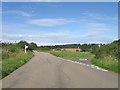

7
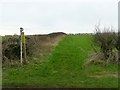
Footpath to Whitwell
Signed as part of the Viking Way.
Image: © Alan Murray-Rust
Taken: 28 Jan 2016
0.18 miles
9

Former telephone box at Exton
This telephone box is now converted to house a Defibrillator
Image: © Bob Harvey
Taken: 20 Oct 2019
0.22 miles
10
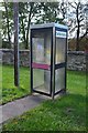
Former telephone box
A fine example of a "modern" 1970s telephone kiosk, now housing a defibrillator
Image: © Bob Harvey
Taken: 20 Oct 2019
0.22 miles