IMAGES TAKEN NEAR TO
Stamford Road, OAKHAM, LE15 8AB
Introduction
This page details the photographs taken nearby to Stamford Road, LE15 8AB by members of the Geograph project.
The Geograph project started in 2005 with the aim of publishing, organising and preserving representative images for every square kilometre of Great Britain, Ireland and the Isle of Man.

There are currently over 7.5m images from over14,400 individuals and you can help contribute to the project by visiting https://www.geograph.org.uk
Image Map (Loading...)


Getting Data...Please wait
Leaflet Map data © OpenStreetMap
Images are licensed for reuse under creativecommons.org/licenses/by-sa/2.0
Notes
- Clicking on the map will re-center to the selected point.
- The higher the marker number, the further away the image location is from the centre of the postcode.
Image Listing (50 Images Found)
Images are licensed for reuse under creativecommons.org/licenses/by-sa/2.0
Image
Details
Distance
2
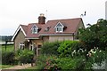
Barnsdale Lodge
The old part of the building with the decorative barge boards was a lodge to Barnsdale. It has been extended considerable as a B&B facility for visitors to Rutland Water.
Image: © Alan Murray-Rust
Taken: 3 Feb 2016
0.02 miles
3
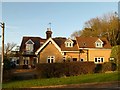
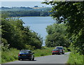
Former main road at Barnsdale
The road ran straight to the clump of trees on the far shore of Rutland Water. At this point the road now forms part of the long distance footpaths - the Hereward Way, the Macmillan Way and the Viking Way.
Image: © Alan Murray-Rust
Taken: 3 Feb 2016
0.02 miles
4
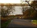
The old turnpike
The old turnpike between Stamford and Oakham became the A606, which in turn was diverted when Rutland Water was built. This section of road is now just access to one of the car parks. Rutland Water is over to the left, and the new A606 way over to the right.
Image: © Graham Horn
Taken: 23 Apr 2007
0.07 miles
5
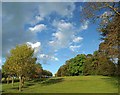
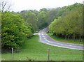
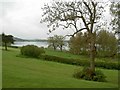
The grounds of Barnsdale Hall Hotel
An avenue of trees surrounding the pitch and putt course.
Image: © Steve Fareham
Taken: 25 Apr 2009
0.07 miles
6

The Viking Way, and Cycle Route 63 near the Barnsdale Country Club
Image: © Tim Heaton
Taken: 31 Jul 2016
0.07 miles
7
Route of the former A606
When Rutland Water was created in 1976 by flooding the Gwash valley, part of the A606 was lost under the water. The road was diverted along the north shore of the reservoir.
Image, the former A606 on the opposite shore of Rutland Reservoir.
Image: © Mat Fascione
Taken: 21 Jun 2014
0.07 miles
8
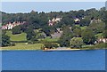
Shoreline at Barnsdale Hotel
Located on the northern arm of Rutland Water, viewed from the Hambleton peninsula.
Image: © Mat Fascione
Taken: 15 Sep 2012
0.07 miles
9
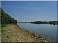
Rutland Shore
Looking along the shoreline of Rutland water. The take off tower is just visible on the right.
Image: © DS Pugh
Taken: 3 Aug 2003
0.09 miles
10
View from Barnsdale Hall grounds
Looking over Rutland water to the Hambleton peninsula.
Image: © Steve Fareham
Taken: 28 Apr 2009
0.11 miles