IMAGES TAKEN NEAR TO
Stableyard Close, OAKHAM, LE15 7UY
Introduction
This page details the photographs taken nearby to Stableyard Close, LE15 7UY by members of the Geograph project.
The Geograph project started in 2005 with the aim of publishing, organising and preserving representative images for every square kilometre of Great Britain, Ireland and the Isle of Man.

There are currently over 7.5m images from over14,400 individuals and you can help contribute to the project by visiting https://www.geograph.org.uk
Image Map
Images are licensed for reuse under creativecommons.org/licenses/by-sa/2.0
Notes
- Clicking on the map will re-center to the selected point.
- The higher the marker number, the further away the image location is from the centre of the postcode.
Image Listing (43 Images Found)
Images are licensed for reuse under creativecommons.org/licenses/by-sa/2.0
Image
Details
Distance
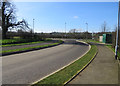
3
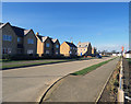
The Avenue
Main entrance road to a new housing estate.
Image: © Andrew Tatlow
Taken: 16 Feb 2016
0.05 miles
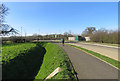
4

The Avenue towards new housing estate
Image: © Andrew Tatlow
Taken: 16 Feb 2016
0.05 miles

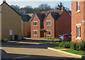
8
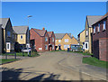
Occupied houses on Wheatfield Way
Part of a new housing estate at Barleythorpe.
Image: © Andrew Tatlow
Taken: 16 Feb 2016
0.06 miles