IMAGES TAKEN NEAR TO
North Brook Close, OAKHAM, LE15 7SD
Introduction
This page details the photographs taken nearby to North Brook Close, LE15 7SD by members of the Geograph project.
The Geograph project started in 2005 with the aim of publishing, organising and preserving representative images for every square kilometre of Great Britain, Ireland and the Isle of Man.

There are currently over 7.5m images from over14,400 individuals and you can help contribute to the project by visiting https://www.geograph.org.uk
Image Map (Loading...)


Getting Data...Please wait
Leaflet Map data © OpenStreetMap
Images are licensed for reuse under creativecommons.org/licenses/by-sa/2.0
Notes
- Clicking on the map will re-center to the selected point.
- The higher the marker number, the further away the image location is from the centre of the postcode.
Image Listing (120 Images Found)
Images are licensed for reuse under creativecommons.org/licenses/by-sa/2.0
Image
Details
Distance
1
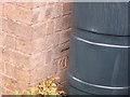
OS Cut Benchmark, Locks Close, Greetham
This is on the side wall of #2. It is easily seen from the pavement. Details at https://www.bench-marks.org.uk/bm99533
Image: © Stephen Armstrong
Taken: 26 Aug 2018
0.06 miles
2
Locks Close, Greetham
There is an OS Cut Benchmark on the side of the house with the tree in the garden. See Image
Image: © Stephen Armstrong
Taken: 26 Aug 2018
0.06 miles
3
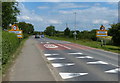
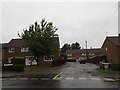
B668 Oakham Road in Greetham
On the western edge of the village.
Image: © Mat Fascione
Taken: 21 Jun 2014
0.13 miles
4
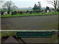
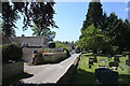
Greetham Burial Ground
Providing additional space for burials once the churchyard was full.
Image: © Alan Murray-Rust
Taken: 19 Jan 2016
0.13 miles
5
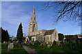
Church of St Mary, Greetham
Dating from the 12th century. For history http://www.greethamchurch.org.uk/greetham-church-history.html
Image: © Tim Heaton
Taken: 24 Jan 2015
0.16 miles
7
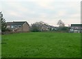
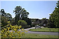
Site of the old Manor House
Bumps and hollows are now all that remain of the medieval manor house. Details of the dates of building seem to be missing, although the manor is recorded as being in the possession of the Earls of Warwick between 1090 and 1491. The site is a Scheduled Monument.
Image: © Alan Murray-Rust
Taken: 19 Jan 2016
0.18 miles
8
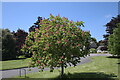
Horse Chestnut in the close
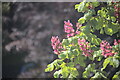
Ornamental planting in the housing estate next to the church.
See Image for a close-up of the blossom.
Image: © Bob Harvey
Taken: 31 May 2021
0.18 miles