IMAGES TAKEN NEAR TO
Bridge Lane, OAKHAM, LE15 7NE
Introduction
This page details the photographs taken nearby to Bridge Lane, LE15 7NE by members of the Geograph project.
The Geograph project started in 2005 with the aim of publishing, organising and preserving representative images for every square kilometre of Great Britain, Ireland and the Isle of Man.

There are currently over 7.5m images from over14,400 individuals and you can help contribute to the project by visiting https://www.geograph.org.uk
Image Map (Loading...)


Getting Data...Please wait
Leaflet Map data © OpenStreetMap
Images are licensed for reuse under creativecommons.org/licenses/by-sa/2.0
Notes
- Clicking on the map will re-center to the selected point.
- The higher the marker number, the further away the image location is from the centre of the postcode.
Image Listing (96 Images Found)
Images are licensed for reuse under creativecommons.org/licenses/by-sa/2.0
Image
Details
Distance
1
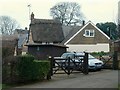
3 Bridge Lane, Greetham (Peep-a-Day Cottage)
18th century stone and thatch cottage, much extended in the 20th century. Listed Grade II for group value.
Image: © Alan Murray-Rust
Taken: 19 Jan 2016
0.01 miles
2
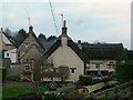
1 Bridge Lane (Bryant's Cottage)
Stone and thatch cottage of around 1700. Listed Grade II. The extension to the right is not mentioned in the listing.
Image: © Alan Murray-Rust
Taken: 19 Jan 2016
0.02 miles
5
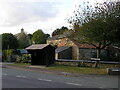
Wooden Bus Shelter, Main Street, Greetham
This image was taken in October 2009. Google Street View from May 2021 shows a new, more open shelter which will not give as much protection in bad weather, but it does have a bench seat inside.
Image: © Stephen Armstrong
Taken: 4 Oct 2009
0.03 miles
6
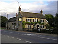
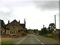
The Wheatsheaf, Stretton Road/Main Street, Greetham
Image: © Stephen Armstrong
Taken: 4 Oct 2009
0.03 miles
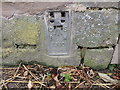
8
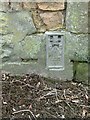
Bench mark, The Wheatsheaf, Greetham
Flush bracket bench mark 1230. It was included on the Castor to Waltham on the Wolds levelling line as part of both the second (1912-21) and third (1950-68) geodetic levellings of England and Wales. See http://www.geograph.org.uk/photo/4803116 for location.
Image: © Alan Murray-Rust
Taken: 19 Jan 2016
0.03 miles
9
OS Flush Bracket on The Wheatsheaf Inn, Greetham
Details at https://www.bench-marks.org.uk/bm1584
Image: © Stephen Armstrong
Taken: 26 Aug 2018
0.03 miles
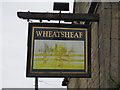
10
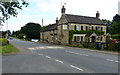
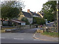
The Wheatsheaf in Greetham
Public house along the Main Street.
Image: © Mat Fascione
Taken: 21 Jun 2014
0.04 miles