IMAGES TAKEN NEAR TO
Burley Road, OAKHAM, LE15 7HY
Introduction
This page details the photographs taken nearby to Burley Road, LE15 7HY by members of the Geograph project.
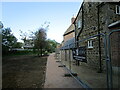
The Geograph project started in 2005 with the aim of publishing, organising and preserving representative images for every square kilometre of Great Britain, Ireland and the Isle of Man.

There are currently over 7.5m images from over14,400 individuals and you can help contribute to the project by visiting https://www.geograph.org.uk
Image Map
Images are licensed for reuse under creativecommons.org/licenses/by-sa/2.0
Notes
- Clicking on the map will re-center to the selected point.
- The higher the marker number, the further away the image location is from the centre of the postcode.
Image Listing (69 Images Found)
Images are licensed for reuse under creativecommons.org/licenses/by-sa/2.0
Image
Details
Distance
1
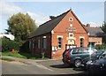
Langham Village Hall
Built as the Village Institute in 1890. This is the first stop on a village trail prepared by the Langham Village History Group.
Image: © Simon Huguet
Taken: 11 Sep 2009
0.07 miles
2
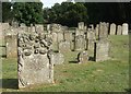
Langham churchyard
A large churchyard lies to the south of the church of SS Peter and Paul, with seried ranks of gravestones in local stone, some with ornate details.
Image: © Simon Huguet
Taken: 11 Sep 2009
0.07 miles
3
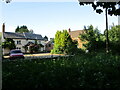
Houses beyond Langham Brook
Langham Brook runs through the centre of the village.
Image: © Jonathan Thacker
Taken: 22 Jun 2021
0.07 miles
4
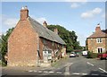
Church Street
Looking back in the general direction of the church.
Image: © Simon Huguet
Taken: 11 Sep 2009
0.08 miles
5
Footpath at Langham
The footpath appears to pass through the garden of this house under restoration.
Image: © Jonathan Thacker
Taken: 22 Jun 2021
0.08 miles
6
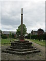
Langham and Barleythorpe war memorial
https://historicengland.org.uk/listing/the-list/list-entry/1454942 Designed by S. Goodhart-Rendel https://en.wikipedia.org/wiki/Harry_Stuart_Goodhart-Rendel
Image: © Jonathan Thacker
Taken: 22 Jun 2021
0.10 miles
7
SS Peter and Paul, Langham
The parish church seen from Church Street.
Image: © Simon Huguet
Taken: 11 Sep 2009
0.10 miles
8
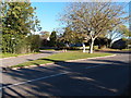
Triangular grass road splitter in Langham
Image: © Michael Trolove
Taken: 3 Nov 2013
0.10 miles
9
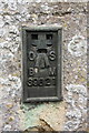
Benchmark on Church of St Peter and St Paul
Ordnance Survey flush bracket (serial identifier S9821) benchmark described on the Bench Mark Database at http://www.bench-marks.org.uk/bm21687
Image: © Roger Templeman
Taken: 29 Apr 2016
0.11 miles
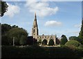
10
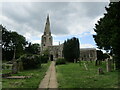
Church of St. Peter and St. Paul, Langham
A largely thirteenth and fourteenth century church https://historicengland.org.uk/listing/the-list/list-entry/1073732
Image: © Jonathan Thacker
Taken: 22 Jun 2021
0.11 miles