IMAGES TAKEN NEAR TO
St. Andrews Close, OAKHAM, LE15 7HD
Introduction
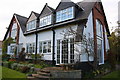
This page details the photographs taken nearby to St. Andrews Close, LE15 7HD by members of the Geograph project.
The Geograph project started in 2005 with the aim of publishing, organising and preserving representative images for every square kilometre of Great Britain, Ireland and the Isle of Man.

There are currently over 7.5m images from over14,400 individuals and you can help contribute to the project by visiting https://www.geograph.org.uk
Image Map
Images are licensed for reuse under creativecommons.org/licenses/by-sa/2.0
Notes
- Clicking on the map will re-center to the selected point.
- The higher the marker number, the further away the image location is from the centre of the postcode.
Image Listing (82 Images Found)
Images are licensed for reuse under creativecommons.org/licenses/by-sa/2.0
Image
Details
Distance
1
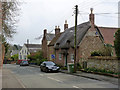
43 Main Street, Whissendine
18th century thatched cottage with a mixture of brick frontage and stone gable. Listed Grade II.
Image: © Alan Murray-Rust
Taken: 28 Mar 2014
0.06 miles
2
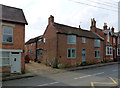
The Old Bakehouse, Main Street
The double-height bays are a distinctive feature of the house. The rear range presumably accommodated the bakery. The building on the left was once a butcher's shop.
Image: © Alan Murray-Rust
Taken: 28 Mar 2014
0.07 miles
3
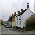
The top of Main Street
A typical English-village mix of housing styles.
Image: © Alan Murray-Rust
Taken: 28 Mar 2014
0.09 miles
4
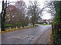
Main Street
Cow Lane goes off to the left in the distance following Whissendine Brook to the left.
Image: © Andrew Tatlow
Taken: 23 Nov 2014
0.10 miles
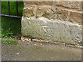
6
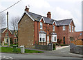
1 Stapleford Road, Whissendine.
There is a bench mark http://www.geograph.org.uk/photo/3911304 on the left hand corner of the gable end.
Image: © Alan Murray-Rust
Taken: 28 Mar 2014
0.10 miles
7
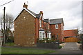
'Ebury House', #1 Stapleford Road
There is an OS benchmark Image on the large quoin at the left front corner of the house
Image: © Roger Templeman
Taken: 29 Apr 2016
0.10 miles
8
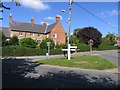
Grass triangle in Whissendine
The junction of Main Street Stapleford Road and Oakham Road in Whissendine
Image: © Andrew Tatlow
Taken: 11 Sep 2007
0.11 miles
9
Bench mark, 1 Stapleford Road, Whissendine
See http://www.geograph.org.uk/photo/3911311 for location.
Image: © Alan Murray-Rust
Taken: 28 Mar 2014
0.11 miles
10
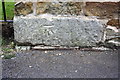
Benchmark on #1 Stapleford Road
Ordnance Survey cut mark benchmark described on the Bench Mark Database at http://www.bench-marks.org.uk/bm56209
Image: © Roger Templeman
Taken: 29 Apr 2016
0.11 miles