IMAGES TAKEN NEAR TO
Oakham Road, OAKHAM, LE15 7HB
Introduction
This page details the photographs taken nearby to Oakham Road, LE15 7HB by members of the Geograph project.
The Geograph project started in 2005 with the aim of publishing, organising and preserving representative images for every square kilometre of Great Britain, Ireland and the Isle of Man.

There are currently over 7.5m images from over14,400 individuals and you can help contribute to the project by visiting https://www.geograph.org.uk
Image Map (Loading...)


Getting Data...Please wait
Leaflet Map data © OpenStreetMap
Images are licensed for reuse under creativecommons.org/licenses/by-sa/2.0
Notes
- Clicking on the map will re-center to the selected point.
- The higher the marker number, the further away the image location is from the centre of the postcode.
Image Listing (88 Images Found)
Images are licensed for reuse under creativecommons.org/licenses/by-sa/2.0
Image
Details
Distance
1
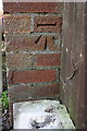
Benchmark on #1 Lammas Cottages
Ordnance Survey cut mark benchmark described on the Bench Mark Database at http://www.bench-marks.org.uk/bm76150
Image: © Roger Templeman
Taken: 29 Apr 2016
0.03 miles
2
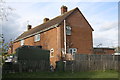
Nos. 1 & 2 Lammas Cottages
There is an OS benchmark Image on the near corner of the houses, right hand face, where the wooden fence abuts
Image: © Roger Templeman
Taken: 29 Apr 2016
0.03 miles
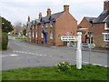
3
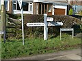
Fingerpost, Oakham Road, Whissendine
Standard Rutland County Council concrete style.
Image: © Alan Murray-Rust
Taken: 28 Jan 2016
0.04 miles
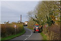
4
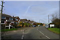
The road from Langham entering Whissendine
Whissendine = Hwicce's Dene, i.e. Hwicce's valley. The Hwicce were a tribe of Anglo-Saxon England. http://kepn.nottingham.ac.uk/map/place/Rutland/Whissendine
Image: © Tim Heaton
Taken: 17 Nov 2017
0.05 miles
5
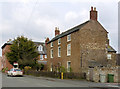
28 Oakham Road, Whissendine
Stone-built farmhouse of around 1800 in the local ironstone with Swithland slate roof. Listed Grade II.
Image: © Alan Murray-Rust
Taken: 28 Mar 2014
0.09 miles
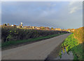
7
Hedge flailing on the edge of Whissendine
Cyclists beware: the detritus from hawthorn hedges - the commonest species in this area - is a major cause of punctures.
Image: © Tim Heaton
Taken: 17 Nov 2017
0.10 miles
8
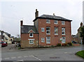
I Bouverie Court, Oakham Road
Georgian or Regency period house on Oakham Road. The main entrance has been moved at some time to the side of the house.
Image: © Alan Murray-Rust
Taken: 28 Mar 2014
0.11 miles
9
Melton Road and Oakham Road junction, Whissendine
The fingerpost is a standard Rutland County Council concrete version, which has been rather crudely repaired at some time.
Image: © Alan Murray-Rust
Taken: 28 Mar 2014
0.11 miles
10
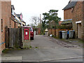
Whissendine West End postbox ref LE15 17
Standard GR wallbox built into a brick pillar.
Image: © Alan Murray-Rust
Taken: 28 Mar 2014
0.11 miles