IMAGES TAKEN NEAR TO
The Glade, Ranksborough Hall, OAKHAM, LE15 7GN
Introduction
This page details the photographs taken nearby to The Glade, Ranksborough Hall, LE15 7GN by members of the Geograph project.
The Geograph project started in 2005 with the aim of publishing, organising and preserving representative images for every square kilometre of Great Britain, Ireland and the Isle of Man.

There are currently over 7.5m images from over14,400 individuals and you can help contribute to the project by visiting https://www.geograph.org.uk
Image Map (Loading...)


Getting Data...Please wait
Leaflet Map data © OpenStreetMap
Images are licensed for reuse under creativecommons.org/licenses/by-sa/2.0
Notes
- Clicking on the map will re-center to the selected point.
- The higher the marker number, the further away the image location is from the centre of the postcode.
Image Listing (8 Images Found)
Images are licensed for reuse under creativecommons.org/licenses/by-sa/2.0
Image
Details
Distance
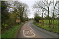
1
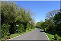
Footpath off Ranksborough Drive, Langham
The footpath to the left skirts round the Ranksborough Hall residential holiday home park, before running west to Ranksborough Hill.
Image: © Tim Heaton
Taken: 20 Apr 2020
0.16 miles
3
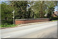
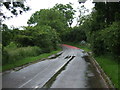
Bridge taking Cold Overton Road over stream
New brick parapet at junction with footpath
Image: © Roger Templeman
Taken: 29 Apr 2016
0.18 miles
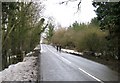
5
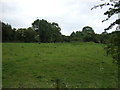
Cold Overton Road entering Langham
Langham = Long Village http://kepn.nottingham.ac.uk/map/place/Rutland/Langham
Image: © Tim Heaton
Taken: 17 Nov 2017
0.20 miles
7
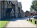
Ranksborough Hall
Right on the northern edge of this square. See http://www.woodgrange.net/ranksborough/home/index.htm for more information about this holiday and mobile home park
Image: © Kate Jewell
Taken: 5 Apr 2006
0.25 miles
8
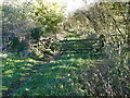
Rutland Round access gates near Langham
The big gate could do with rehanging,
Image: © Michael Trolove
Taken: 3 Nov 2013
0.25 miles