IMAGES TAKEN NEAR TO
Westland Road, OAKHAM, LE15 7DT
Introduction
This page details the photographs taken nearby to Westland Road, LE15 7DT by members of the Geograph project.
The Geograph project started in 2005 with the aim of publishing, organising and preserving representative images for every square kilometre of Great Britain, Ireland and the Isle of Man.

There are currently over 7.5m images from over14,400 individuals and you can help contribute to the project by visiting https://www.geograph.org.uk
Image Map (Loading...)


Getting Data...Please wait
Leaflet Map data © OpenStreetMap
Images are licensed for reuse under creativecommons.org/licenses/by-sa/2.0
Notes
- Clicking on the map will re-center to the selected point.
- The higher the marker number, the further away the image location is from the centre of the postcode.
Image Listing (16 Images Found)
Images are licensed for reuse under creativecommons.org/licenses/by-sa/2.0
Image
Details
Distance
1
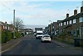
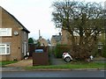
Westland Road, Cottesmore
Housing estate from the second half of the 20th century.
Image: © Alan Murray-Rust
Taken: 19 Jan 2016
0.06 miles
3
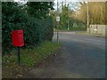
Nether Close postbox, Cottesmore Ref.LE15 7
Standard EIIR lampbox on post, missing its information plate.
Image: © Alan Murray-Rust
Taken: 19 Jan 2016
0.10 miles
4
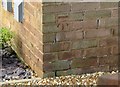
Bench mark, 16 Greetham Road, Cottesmore
See http://www.geograph.org.uk/photo/4801058 for location.
Image: © Alan Murray-Rust
Taken: 19 Jan 2016
0.11 miles
5
Footpath through the estate
Linking Greetham Road with Westland Road. There is a bench mark http://www.geograph.org.uk/photo/4801056 on the side of the house to the left.
Image: © Alan Murray-Rust
Taken: 19 Jan 2016
0.11 miles
6
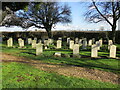
War graves, Cottesmore
Mainly of post WW2 British service personnel.
Image: © Jonathan Thacker
Taken: 22 Feb 2022
0.14 miles
7
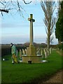
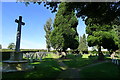
War graves at Cottesmore Cemetery
The memorial cross was being given an annual clean up by the Commonwealth War Graves Commissions man. The graves all relate to men stationed at RAF Cottesmore. The cross itself has no inscriptions.
Image: © Alan Murray-Rust
Taken: 19 Jan 2016
0.15 miles
8
Rogues Lane
Originally a country lane leading towards Thistleton, it became the main access to RAF Cottesmore, now Kendrew Barracks. The name apparently derives from an unauthorised band of travellers who set up in the 1800s.
Image: © Alan Murray-Rust
Taken: 19 Jan 2016
0.16 miles
9
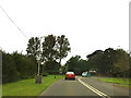
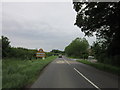
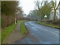
B668 in Cottesmore
A tight bend in the road
Image: © Andrew Abbott
Taken: 1 Sep 2012
0.16 miles
10
Cottesmore Cemetery (St Nicholas churchyard extension)
A war graves plot for airmen of the RAF and commonwealth air forces
Image: © Tim Heaton
Taken: 3 Oct 2016
0.16 miles