IMAGES TAKEN NEAR TO
Bedale Street, OAKHAM, LE15 7AF
Introduction
This page details the photographs taken nearby to Bedale Street, LE15 7AF by members of the Geograph project.
The Geograph project started in 2005 with the aim of publishing, organising and preserving representative images for every square kilometre of Great Britain, Ireland and the Isle of Man.

There are currently over 7.5m images from over14,400 individuals and you can help contribute to the project by visiting https://www.geograph.org.uk
Image Map
Images are licensed for reuse under creativecommons.org/licenses/by-sa/2.0
Notes
- Clicking on the map will re-center to the selected point.
- The higher the marker number, the further away the image location is from the centre of the postcode.
Image Listing (6 Images Found)
Images are licensed for reuse under creativecommons.org/licenses/by-sa/2.0
Image
Details
Distance
1
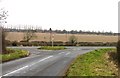
Junction with B668 Greetham Road
Housing at RAF Cottesmore is visible in the background.
Image: © Andrew Tatlow
Taken: 1 Feb 2009
0.11 miles
3

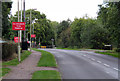
Towards Cottesmore
Accommodation at RAF Cottesmore is in the distance.
Image: © Andrew Tatlow
Taken: 1 Feb 2009
0.15 miles
4
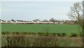
View towards Kendrew Barracks
Armed forces housing, formerly RAF Cottesmore.
Image: © Alan Murray-Rust
Taken: 28 Jan 2016
0.20 miles
6

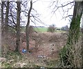
Rogue's Lane towards Kendrew Barracks
Image: © Andrew Tatlow
Taken: 16 Sep 2016
0.24 miles