IMAGES TAKEN NEAR TO
Chater Road, OAKHAM, LE15 6RY
Introduction
This page details the photographs taken nearby to Chater Road, LE15 6RY by members of the Geograph project.
The Geograph project started in 2005 with the aim of publishing, organising and preserving representative images for every square kilometre of Great Britain, Ireland and the Isle of Man.

There are currently over 7.5m images from over14,400 individuals and you can help contribute to the project by visiting https://www.geograph.org.uk
Image Map
Images are licensed for reuse under creativecommons.org/licenses/by-sa/2.0
Notes
- Clicking on the map will re-center to the selected point.
- The higher the marker number, the further away the image location is from the centre of the postcode.
Image Listing (11 Images Found)
Images are licensed for reuse under creativecommons.org/licenses/by-sa/2.0
Image
Details
Distance
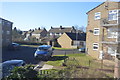
2
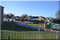
Brooke Hill County Primary School
A very popular primary school on the outskirts of Oakham.
Image: © Andrew Tatlow
Taken: 28 Apr 2006
0.15 miles
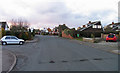
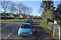
3
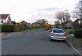
Brooke Road
Most of the houses on this side of Oakham have been built since the Second World War.
Image: © Andrew Tatlow
Taken: 28 Apr 2006
0.16 miles
6
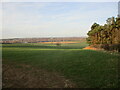
Distant view of Oakham
Brooke Covert East on the right.
Image: © Jonathan Thacker
Taken: 26 Feb 2022
0.23 miles
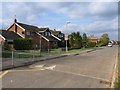
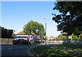
7
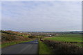
Looking down Brooke Hill towards Oakham
Oakham, the county town of Rutland, is undergoing considerable expansion since the building of its bypass
Image: © Tim Heaton
Taken: 13 Mar 2018
0.24 miles
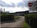
9
A train at Brooke Road level crossing
Image: © Andrew Tatlow
Taken: 30 Sep 2011
0.25 miles