IMAGES TAKEN NEAR TO
Balmoral Road, OAKHAM, LE15 6RT
Introduction
This page details the photographs taken nearby to Balmoral Road, LE15 6RT by members of the Geograph project.
The Geograph project started in 2005 with the aim of publishing, organising and preserving representative images for every square kilometre of Great Britain, Ireland and the Isle of Man.

There are currently over 7.5m images from over14,400 individuals and you can help contribute to the project by visiting https://www.geograph.org.uk
Image Map
Images are licensed for reuse under creativecommons.org/licenses/by-sa/2.0
Notes
- Clicking on the map will re-center to the selected point.
- The higher the marker number, the further away the image location is from the centre of the postcode.
Image Listing (6 Images Found)
Images are licensed for reuse under creativecommons.org/licenses/by-sa/2.0
Image
Details
Distance
1
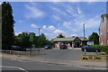
Local Co-op Food store, West Road, Oakham
"... there are over 4,000 co-operative food shops in the UK, more outlets than any other grocer." https://en.wikipedia.org/wiki/Co-op_Food
Image: © Tim Heaton
Taken: 6 Aug 2018
0.15 miles
2
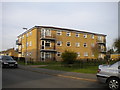
Low rise flats on Derwent Drive, Oakham
The northernmost of three similar blocks on Derwent Drive.
Image: © Richard Vince
Taken: 8 Mar 2014
0.21 miles
4
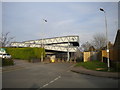
Footbridge from Braunston Road to South Street, Oakham
From the road layout, I assume there was once a level crossing here.
Image: © Richard Vince
Taken: 8 Mar 2014
0.23 miles
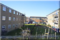
5
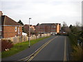
The Sidings, Oakham
A recent residential cul de sac off South Street, running parallel to the railway (hence the name).
Image: © Richard Vince
Taken: 8 Mar 2014
0.24 miles