IMAGES TAKEN NEAR TO
Burley Road, OAKHAM, LE15 6DL
Introduction
This page details the photographs taken nearby to Burley Road, LE15 6DL by members of the Geograph project.
The Geograph project started in 2005 with the aim of publishing, organising and preserving representative images for every square kilometre of Great Britain, Ireland and the Isle of Man.

There are currently over 7.5m images from over14,400 individuals and you can help contribute to the project by visiting https://www.geograph.org.uk
Image Map
Images are licensed for reuse under creativecommons.org/licenses/by-sa/2.0
Notes
- Clicking on the map will re-center to the selected point.
- The higher the marker number, the further away the image location is from the centre of the postcode.
Image Listing (35 Images Found)
Images are licensed for reuse under creativecommons.org/licenses/by-sa/2.0
Image
Details
Distance
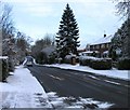
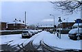
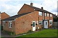
1
Semi-detached houses on Burley Road
The left hand house is #101
Image: © Roger Templeman
Taken: 5 Apr 2016
0.01 miles
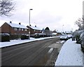
5
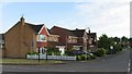
Houses on Heron Way
The new Oakham bypass will run across the end of this road.
Image: © Andrew Tatlow
Taken: 11 Jun 2006
0.13 miles
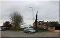
6
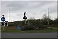
Bird sculpture on the roundabout on Burley Road, Oakham
Image: © David Howard
Taken: 6 Apr 2019
0.14 miles
7
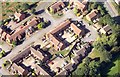
Ladywell, Oakham from the air
From flight over Oakham
Image: © Graham Stuart Broughton
Taken: 3 Sep 2013
0.16 miles
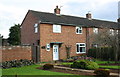
8
#33 Ashwell Road with extension on NE face
Image: © Roger Templeman
Taken: 5 Apr 2016
0.16 miles
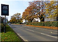
9
Ashwell Road towards the centre of Oakham
Image: © Andrew Tatlow
Taken: 27 Nov 2010
0.16 miles