IMAGES TAKEN NEAR TO
Burgess Street, LEICESTER, LE1 4QH
Introduction
This page details the photographs taken nearby to Burgess Street, LE1 4QH by members of the Geograph project.
The Geograph project started in 2005 with the aim of publishing, organising and preserving representative images for every square kilometre of Great Britain, Ireland and the Isle of Man.

There are currently over 7.5m images from over14,400 individuals and you can help contribute to the project by visiting https://www.geograph.org.uk
Image Map
Images are licensed for reuse under creativecommons.org/licenses/by-sa/2.0
Notes
- Clicking on the map will re-center to the selected point.
- The higher the marker number, the further away the image location is from the centre of the postcode.
Image Listing (276 Images Found)
Images are licensed for reuse under creativecommons.org/licenses/by-sa/2.0
Image
Details
Distance
1
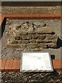
Section of Leicester's Roman town wall
This is the only part of Leicester's Roman town wall so far discovered with the original facing stones intact. The facing stones only survived because the wall had collapsed onto its face. Elsewhere these stones have been robbed or quarried away to be reused in other buildings.
The wall was discovered during one of Leicester's largest archaeological excavations which took place prior to the construction of the new buildings at Leicester Square. This piece of wall was moved here from the basement area of Burgess House so it could be displayed.
The wall enclosed the Roman town, it was almost 3m wide and probably 5m high, and most likely constructed in the 3rd century AD.
Image: © Mat Fascione
Taken: 31 Jul 2020
0.01 miles
5
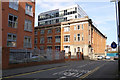
Chimney Apartments, Junior Street, Leicester
A grade II listed building from 1915, formerly the Richard Roberts hosiery factory. The 2004 listing citation mentions its open plan interior as surviving, which is hard to reconcile with it being now divided up into flats.
Image: © Robin Webster
Taken: 25 Mar 2016
0.03 miles
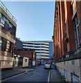
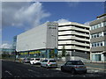
8
Long Lane entrance to multi-storey carpark at John Lewis store
Image: © Roger Templeman
Taken: 11 May 2018
0.05 miles
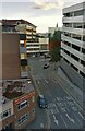
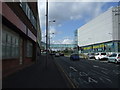
9
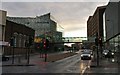
Vaughan Way in Leicester
The A594 Vaughan Way is part of Leicester's inner ring road. The footbridge links the John Lewis department store to a 2000-space car park, at the Highcross Shopping Centre.
Image: © Mat Fascione
Taken: 24 Sep 2020
0.05 miles
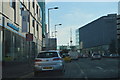
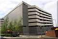
10

Highcross Shopping Centre in Leicester
The shopping centre was opened as The Shires in 1991, it was extended in 1994. A further large extension opened in 2008, when the entire centre was renamed Highcross Leicester. On the left is the John Lewis department store, linked by a glass footbridge to a 2000-space car park on the right.
The footbridge is crossing Vaughan Way.
Image: © Mat Fascione
Taken: 14 Jan 2018
0.06 miles