IMAGES TAKEN NEAR TO
Eastwell Road, MELTON MOWBRAY, LE14 4SS
Introduction
This page details the photographs taken nearby to Eastwell Road, LE14 4SS by members of the Geograph project.
The Geograph project started in 2005 with the aim of publishing, organising and preserving representative images for every square kilometre of Great Britain, Ireland and the Isle of Man.

There are currently over 7.5m images from over14,400 individuals and you can help contribute to the project by visiting https://www.geograph.org.uk
Image Map
Images are licensed for reuse under creativecommons.org/licenses/by-sa/2.0
Notes
- Clicking on the map will re-center to the selected point.
- The higher the marker number, the further away the image location is from the centre of the postcode.
Image Listing (23 Images Found)
Images are licensed for reuse under creativecommons.org/licenses/by-sa/2.0
Image
Details
Distance
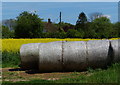
2
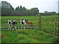
Calves at Red House Farm
Very friendly they were too!
Image: © Kate Jewell
Taken: 17 Oct 2005
0.07 miles
3
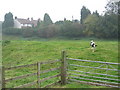
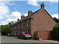
Field at Red House Farm, Leicestershire
This field is on the site of an old brick works and quarry. The row of cottages are brick built, unusual for this area where most houses are stone.
Image: © Kate Jewell
Taken: 17 Oct 2005
0.08 miles
4
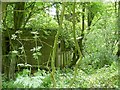
Remains of the Lionville brickworks, Scalford
A view of the remains of Lionville brickworks from the entrance. Nature has largely reclaimed the site.
Image: © Richard Green
Taken: 3 Aug 2013
0.11 miles
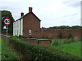
5
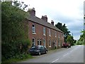
Lionville Cottages, Scalford, from the east
This attractive terrace of cottages was built by the proprietors of the Lionville brickworks (which closed around the time of WWII) for their workers.
Image: © Richard Green
Taken: 3 Aug 2013
0.11 miles
6
Lionville Cottages, Scalford, from the west
This row of cottages was built to house workers at the Lionville brickworks. This closed around the time of WWII, and was situated just beyond the cottages,
Image: © Richard Green
Taken: 3 Aug 2013
0.12 miles
7
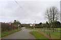
Cranyke Farm near Eastwell, Leicestershire
The road crosses a deep cutting here that used to be part of the iron stone mineral railway system. Cranyke Farm is a large iron stone three story house.
Image: © Kate Jewell
Taken: 26 Mar 2006
0.13 miles
8
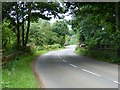
Landyke Lane (Roman road) approaching the road from Eastwell to Scalford
The Roman road, the 'Salt Way', continues straight ahead.
Image: © Tim Heaton
Taken: 17 Jan 2021
0.13 miles
9
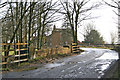
Bridge HLB17 over disused mineral railway
This stone arch bridge carries the Scalford - Eastwell road over the abandoned mineral railway which once ran from Holwell Junction to Wycomb Junction, built to carry ironstone from the numerous quarries which once peppered the Belvoir escarpment. The bridge is still maintained by British Rail's successors, and has ELR asset code HLB17.
Image: © Richard Green
Taken: 3 Aug 2013
0.13 miles