IMAGES TAKEN NEAR TO
Waltham Road, MELTON MOWBRAY, LE14 4SD
Introduction
This page details the photographs taken nearby to Waltham Road, LE14 4SD by members of the Geograph project.
The Geograph project started in 2005 with the aim of publishing, organising and preserving representative images for every square kilometre of Great Britain, Ireland and the Isle of Man.

There are currently over 7.5m images from over14,400 individuals and you can help contribute to the project by visiting https://www.geograph.org.uk
Image Map
Images are licensed for reuse under creativecommons.org/licenses/by-sa/2.0
Notes
- Clicking on the map will re-center to the selected point.
- The higher the marker number, the further away the image location is from the centre of the postcode.
Image Listing (12 Images Found)
Images are licensed for reuse under creativecommons.org/licenses/by-sa/2.0
Image
Details
Distance
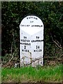
4
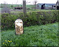
Milepost along the A607
It has got very rusty in the last seven years, Image
Image: © Mat Fascione
Taken: 14 Apr 2014
0.03 miles
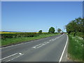

9
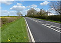
A607 at Thorpe Arnold
Looking north east from the edge of the village
Image: © Kate Jewell
Taken: 16 Nov 2005
0.14 miles
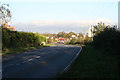
10
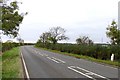
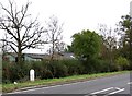
A607 towards Grantham
The next village is Waltham on the Wolds
Image: © Andrew Tatlow
Taken: 27 Oct 2007
0.16 miles