IMAGES TAKEN NEAR TO
Stonesby Road, MELTON MOWBRAY, LE14 4RF
Introduction
This page details the photographs taken nearby to Stonesby Road, LE14 4RF by members of the Geograph project.
The Geograph project started in 2005 with the aim of publishing, organising and preserving representative images for every square kilometre of Great Britain, Ireland and the Isle of Man.

There are currently over 7.5m images from over14,400 individuals and you can help contribute to the project by visiting https://www.geograph.org.uk
Image Map
Images are licensed for reuse under creativecommons.org/licenses/by-sa/2.0
Notes
- Clicking on the map will re-center to the selected point.
- The higher the marker number, the further away the image location is from the centre of the postcode.
Image Listing (21 Images Found)
Images are licensed for reuse under creativecommons.org/licenses/by-sa/2.0
Image
Details
Distance
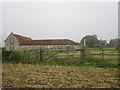
1
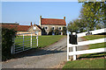
Lower Farm, Saltby
A fairly modest farmhouse by some extensive old and modern farm buildings.
Image: © Kate Jewell
Taken: 23 Oct 2007
0.05 miles
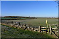
2
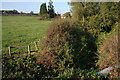
Countryside near Saltby
Somewhere amongst this hawthorn scrub is the River Eye! Looking upstream towards High Dyke House.
Image: © Kate Jewell
Taken: 23 Oct 2007
0.06 miles
3
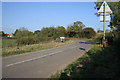
Coming into Saltby
As you enter the village along the Stonesby road you cross the River Eye just before the double bend.
Image: © Kate Jewell
Taken: 23 Oct 2007
0.09 miles
4
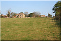
Saltby from the footpath
St Michael's Farm on the horizon.
Image: © Kate Jewell
Taken: 23 Oct 2007
0.10 miles
5
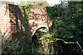
Bridge over the River Eye
The river is very small here, only 3 kilometres from the source at Bescaby, see Image
Image: © Kate Jewell
Taken: 23 Oct 2007
0.10 miles
6
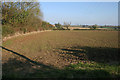
Farmland near Saltby
Looking in the Saltby direction. The road from Stonesby is just the other side of the hedge on the left.
Image: © Kate Jewell
Taken: 23 Oct 2007
0.13 miles
7
St. Michael's Farm
On a misty autumn morning that turned into a very sunny and hot afternoon.
Image: © Jonathan Thacker
Taken: 14 Sep 2016
0.15 miles
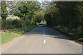
8
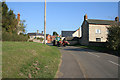
Stonesby Road, Saltby
Looking towards the centre of the village.
Image: © Kate Jewell
Taken: 23 Oct 2007
0.15 miles
9
Footpath leading north-west from Saltby
Heading towards Croxton Park across the flatter lands above the Leicestershire Wolds
Image: © Tim Heaton
Taken: 23 Jan 2019
0.16 miles
10
Country road to Saltby
The village can be seen through the trees on the left.
Image: © Kate Jewell
Taken: 23 Oct 2007
0.16 miles