IMAGES TAKEN NEAR TO
Saltby Road, MELTON MOWBRAY, LE14 4RA
Introduction
This page details the photographs taken nearby to Saltby Road, LE14 4RA by members of the Geograph project.
The Geograph project started in 2005 with the aim of publishing, organising and preserving representative images for every square kilometre of Great Britain, Ireland and the Isle of Man.

There are currently over 7.5m images from over14,400 individuals and you can help contribute to the project by visiting https://www.geograph.org.uk
Image Map
Images are licensed for reuse under creativecommons.org/licenses/by-sa/2.0
Notes
- Clicking on the map will re-center to the selected point.
- The higher the marker number, the further away the image location is from the centre of the postcode.
Image Listing (9 Images Found)
Images are licensed for reuse under creativecommons.org/licenses/by-sa/2.0
Image
Details
Distance
1
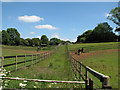
Sproxton: paddocks where ironstone was once quarried
The paddocks and gallops of Derek Shaw's yard at Sproxton occupy land which was from 1921-61 Sproxton No 1 ironstone quarry. The yard's postal address is "The Sidings", Saltby Road - to most people, I imagine, a mystifying name as there is now no evidence of the quarry or the railway which served it.
The Great Northern Railway extended the High Dyke Branch from Skillington Junction to Sproxton c. 1920. The terminus, sidings and quarry company engine shed were behind the line of trees on the left, and the steam-worked quarry railway (originally, for just a few years, horse-worked) came down a steep curve to the Saltby road, where I stood to take this picture. No 1 quarry and its railway eventually extended as far south as the Skillington road. Lorries replaced the quarry railway at Sproxton in 1963, but the ore - from outlying quarries developed in the 1960s - was shipped out along the High Dyke Branch for another ten years. The last train of ore from Sproxton to High Dyke was on 3 April 1973.
Image: © John Sutton
Taken: 17 Jun 2010
0.10 miles
2
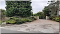
Entrance to The Sidings from east side of Saltby Road
The name of the premises derives from the railway which once ran from an ironstone quarry at this location. The last train of ore was on 3 April 1973
Image: © Luke Shaw
Taken: 28 Jun 2023
0.17 miles
3
Reminder of the ironstone railway at Sproxton
The paddocks and gallops of Derek Shaw's yard at Sproxton occupy land which was from 1921-61 Sproxton No 1 ironstone quarry. The yard's postal address is "The Sidings", Saltby Road - to most people, I imagine, a mystifying name as there is now no evidence of the quarry or the railway which served it. This picture of the nameboard is taken from the drive to the house, looking towards Bescaby.
Image: © John Sutton
Taken: 17 Jun 2010
0.17 miles
4
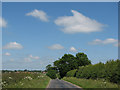
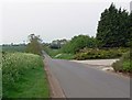
Big-sky country
The Sproxton to Saltby road, looking towards the pantiled roofs of Saltby. The reclaimed land over the hedge to the right, now Derek Shaw Racing Ltd, was from 1921-61 the huge Sproxton No 1 ironstone quarry. The High Dyke Branch railway terminated at the Saltby road about 200 yards north of here, but there is now nothing to see. The picture shows the wide-open limestone country and big sky of this part of north Leicestershire and South Lincolnshire.
Image: © John Sutton
Taken: 17 Jun 2010
0.19 miles
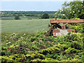
6
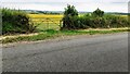
View through gateway on west side of Saltby Road opposite The Sidings
Image: © Roger Templeman
Taken: 28 Jun 2023
0.21 miles
7
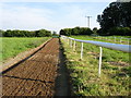
Private race track, Sproxton
This small oval training track is tucked away behind the Church. The white railings follow it all the way round and are made of plastic.
Image: © Kate Jewell
Taken: 15 Aug 2005
0.21 miles
8
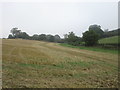
View towards the Saltby to Sproxton road
Taken from the footpath between the two villages.
Image: © Jonathan Thacker
Taken: 14 Sep 2016
0.23 miles
9
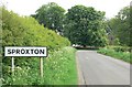
Approaching Sproxton from the north
The Church of St Bartholomew is visible through the trees.
Image: © Mat Fascione
Taken: 10 May 2008
0.24 miles