IMAGES TAKEN NEAR TO
Main Street, MELTON MOWBRAY, LE14 4QH
Introduction
This page details the photographs taken nearby to Main Street, LE14 4QH by members of the Geograph project.
The Geograph project started in 2005 with the aim of publishing, organising and preserving representative images for every square kilometre of Great Britain, Ireland and the Isle of Man.

There are currently over 7.5m images from over14,400 individuals and you can help contribute to the project by visiting https://www.geograph.org.uk
Image Map
Images are licensed for reuse under creativecommons.org/licenses/by-sa/2.0
Notes
- Clicking on the map will re-center to the selected point.
- The higher the marker number, the further away the image location is from the centre of the postcode.
Image Listing (29 Images Found)
Images are licensed for reuse under creativecommons.org/licenses/by-sa/2.0
Image
Details
Distance
1
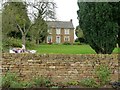
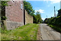
Stowleigh, Main Road, Wycomb
Former farmhouse, built 1850, ironstone with limestone dressings, Listed Grade II.
Image: © Alan Murray-Rust
Taken: 7 Nov 2016
0.03 miles
2
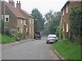
Pickards Lane, Wycomb
Another tiny village in the depths of the Leicestershire countryside. Wycomb, Chadwell Image and Goadby Marwood Image are very much off the beaten track.
Image: © Kate Jewell
Taken: 17 Oct 2005
0.07 miles
3
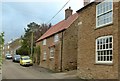
The Homestead, Main Road Wycomb
18th century ironstone cottage with pantiled roof, Listed Grade II.
Image: © Alan Murray-Rust
Taken: 7 Nov 2016
0.07 miles
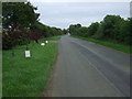
7
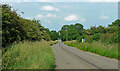
Country road near Wycomb (2)
Looking east towards Chadwell.
Image: © Stephen Richards
Taken: 25 Jun 2015
0.08 miles
8
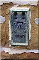
Benchmark on Manor Farm
Ordnance Survey flush bracket (serial number 1169) benchmark described on the Bench Mark Database at www.bench-marks.oeg.uk/bm1964
Image: © Roger Templeman
Taken: 7 May 2017
0.08 miles
9
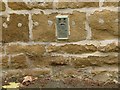
Flush bracket bench mark, Main Road, Wycomb
Used during the Second (1912-21) and Third (1950-68) levellings of England and Wales. http://www.bench-marks.org.uk/bm1964 . See http://www.geograph.org.uk/photo/5188591 for location.
Image: © Alan Murray-Rust
Taken: 7 Nov 2016
0.08 miles
10
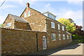
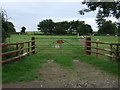
Manor Farm, Main Road
There is an OS benchmark Image near the corner of the house right of the grey door
Image: © Roger Templeman
Taken: 7 May 2017
0.08 miles