IMAGES TAKEN NEAR TO
Melton Road, MELTON MOWBRAY, LE14 4NT
Introduction
This page details the photographs taken nearby to Melton Road, LE14 4NT by members of the Geograph project.
The Geograph project started in 2005 with the aim of publishing, organising and preserving representative images for every square kilometre of Great Britain, Ireland and the Isle of Man.

There are currently over 7.5m images from over14,400 individuals and you can help contribute to the project by visiting https://www.geograph.org.uk
Image Map
Images are licensed for reuse under creativecommons.org/licenses/by-sa/2.0
Notes
- Clicking on the map will re-center to the selected point.
- The higher the marker number, the further away the image location is from the centre of the postcode.
Image Listing (9 Images Found)
Images are licensed for reuse under creativecommons.org/licenses/by-sa/2.0
Image
Details
Distance
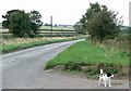
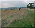
2
Melton Road descends Clawson Hill
The houses in the distance are on Coronation Avenue in Long Clawson.
Image: © Mat Fascione
Taken: 30 Aug 2008
0.09 miles
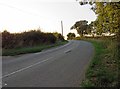
6
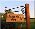
Clawson Hill Farm sign
It's a lighted sign as well!
Image: © Andrew Tatlow
Taken: 31 Aug 2018
0.21 miles
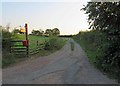
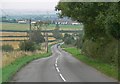
9
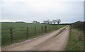
The track to Clawson Hill Farm
Looks isolated and bleak on a cold February afternoon.
Image: © Jonathan Thacker
Taken: 4 Feb 2012
0.24 miles