IMAGES TAKEN NEAR TO
Main Street, MELTON MOWBRAY, LE14 4LP
Introduction
This page details the photographs taken nearby to Main Street, LE14 4LP by members of the Geograph project.
The Geograph project started in 2005 with the aim of publishing, organising and preserving representative images for every square kilometre of Great Britain, Ireland and the Isle of Man.

There are currently over 7.5m images from over14,400 individuals and you can help contribute to the project by visiting https://www.geograph.org.uk
Image Map
Images are licensed for reuse under creativecommons.org/licenses/by-sa/2.0
Notes
- Clicking on the map will re-center to the selected point.
- The higher the marker number, the further away the image location is from the centre of the postcode.
Image Listing (17 Images Found)
Images are licensed for reuse under creativecommons.org/licenses/by-sa/2.0
Image
Details
Distance
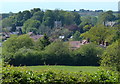
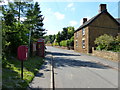
1
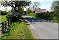
Main Street heading into Goadby Marwood
Image: © Mat Fascione
Taken: 27 May 2013
0.05 miles
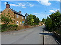
3
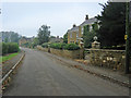
Main Street, Goadby Marwood
A mix of large houses and tiny cottages in this small ironstone village
Image: © Kate Jewell
Taken: 17 Oct 2005
0.13 miles
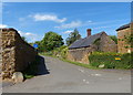
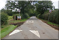
4
Goadby Marwood
The village of Goadby Marwood is at the end of a road so there is no through traffic.
Image: © Andrew Tatlow
Taken: 24 Nov 2010
0.13 miles
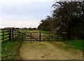
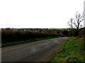
6
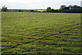
Farmland near Goadby Marwood
This large paddock is one of several.
Image: © Kate Jewell
Taken: 8 Oct 2008
0.15 miles