IMAGES TAKEN NEAR TO
Eastwell Road, MELTON MOWBRAY, LE14 4ES
Introduction
This page details the photographs taken nearby to Eastwell Road, LE14 4ES by members of the Geograph project.
The Geograph project started in 2005 with the aim of publishing, organising and preserving representative images for every square kilometre of Great Britain, Ireland and the Isle of Man.

There are currently over 7.5m images from over14,400 individuals and you can help contribute to the project by visiting https://www.geograph.org.uk
Image Map
Images are licensed for reuse under creativecommons.org/licenses/by-sa/2.0
Notes
- Clicking on the map will re-center to the selected point.
- The higher the marker number, the further away the image location is from the centre of the postcode.
Image Listing (19 Images Found)
Images are licensed for reuse under creativecommons.org/licenses/by-sa/2.0
Image
Details
Distance
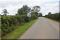
1
The road from Waltham on the Wolds to Eastwell
Image: © Tim Heaton
Taken: 17 Jan 2021
0.05 miles
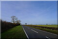
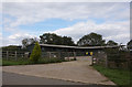
2

Country road heading north
Towards White Lodge.
Image: © JThomas
Taken: 17 Aug 2013
0.06 miles

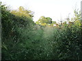
4
Line of the bridleway to Goadby Marwood and Chadwell
Looking in the opposite direction from Image
Image: © Kate Jewell
Taken: 8 Oct 2008
0.10 miles
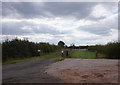
7
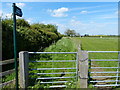
Public bridleway heading north from Main Street
Image: © Mat Fascione
Taken: 27 May 2013
0.17 miles
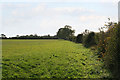
9
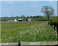
Fields east of Goadby Marwood
The hedgerow on the right is along the lane leading towards Waltham on the Wolds.
Image: © Mat Fascione
Taken: 27 May 2013
0.19 miles