IMAGES TAKEN NEAR TO
Stathern Road, MELTON MOWBRAY, LE14 4EN
Introduction
This page details the photographs taken nearby to Stathern Road, LE14 4EN by members of the Geograph project.
The Geograph project started in 2005 with the aim of publishing, organising and preserving representative images for every square kilometre of Great Britain, Ireland and the Isle of Man.

There are currently over 7.5m images from over14,400 individuals and you can help contribute to the project by visiting https://www.geograph.org.uk
Image Map
Images are licensed for reuse under creativecommons.org/licenses/by-sa/2.0
Notes
- Clicking on the map will re-center to the selected point.
- The higher the marker number, the further away the image location is from the centre of the postcode.
Image Listing (47 Images Found)
Images are licensed for reuse under creativecommons.org/licenses/by-sa/2.0
Image
Details
Distance


5
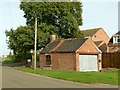
Former smithy, Eastwell
Now a private garage, but the former function is immediately evident from the style of the building.
Image: © Alan Murray-Rust
Taken: 31 Oct 2016
0.14 miles
6
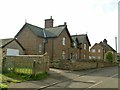
The Cottage, Main Street, Eastwell
A pair of 19th century cottages, almost certainly built by the Belvoir Estate.
Image: © Alan Murray-Rust
Taken: 31 Oct 2016
0.14 miles
7
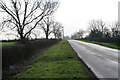
Looking south towards Eastwell
On Stathern Road just south of Lodge Farm.
Image: © Kate Jewell
Taken: 30 Jan 2008
0.14 miles
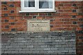
8
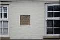
Datestone
Datestone for 1843 on the second of Image
Image: © Bob Harvey
Taken: 10 Mar 2016
0.15 miles
9

The village of Eastwell in Leicestershire
Image: © Mat Fascione
Taken: 5 Jun 2010
0.15 miles
10
Datestone
Datestone for 1834 on the first of the Image
Image: © Bob Harvey
Taken: 10 Mar 2016
0.15 miles