IMAGES TAKEN NEAR TO
Harefield Close, LE14 4DU
Introduction
This page details the photographs taken nearby to Harefield Close, LE14 4DU by members of the Geograph project.
The Geograph project started in 2005 with the aim of publishing, organising and preserving representative images for every square kilometre of Great Britain, Ireland and the Isle of Man.

There are currently over 7.5m images from over14,400 individuals and you can help contribute to the project by visiting https://www.geograph.org.uk
Image Map
Images are licensed for reuse under creativecommons.org/licenses/by-sa/2.0
Notes
- Clicking on the map will re-center to the selected point.
- The higher the marker number, the further away the image location is from the centre of the postcode.
Image Listing (45 Images Found)
Images are licensed for reuse under creativecommons.org/licenses/by-sa/2.0
Image
Details
Distance
1
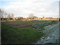
Allotments at Harby
Looking ready for a new growing season.
Image: © Jonathan Thacker
Taken: 3 Feb 2012
0.08 miles
2
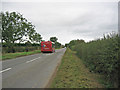
Stathern Road, near Harby
The Vale Hopper is a County Council sponsored bus service covering most of the Leicestershire Vale of Belvoir villages between Melton and Bottesford. It is unusual for a country bus as it runs frequently and also into the evening, servicing late night activities at the big upper school in Melton where most of the Vale students go.
Image: © Kate Jewell
Taken: 14 Oct 2005
0.14 miles
3
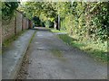
Gas Walk, Harby
There is no evidence of there ever having been a gas works in the village. The word 'gas' may be related to the German word 'Gasse' which means an alley, and which is related to the Scandinavian-based 'gate' meaning a thoroughfare.
In highways terms, it is classified as a public footpath. There are 'No Cycling' signs at the ends, but you can drive a car along to access the houses which abut it!
Image: © Alan Murray-Rust
Taken: 23 Oct 2016
0.14 miles
5
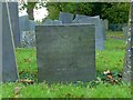
Belvoir Angel headstone, Harby Churchyard
To Elizabeth, wife of Ralph Whittle Senr., d.1716.
Image: © Alan Murray-Rust
Taken: 23 Oct 2016
0.17 miles
6
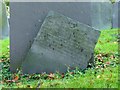
Belvoir Angel headstone, Harby Churchyard
To John, son of Tho. And Eliz. Hand, d.1727.
Image: © Alan Murray-Rust
Taken: 23 Oct 2016
0.17 miles
7
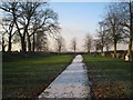
Churchyard extension, Harby
A very formal layout.
Image: © Jonathan Thacker
Taken: 3 Feb 2012
0.17 miles
8
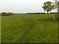
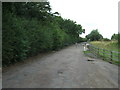
Footpath crossroads
The footpath on which the photographer is standing continues to the gap in the hedge by the solitary tree, but is clearly hardly used compared with the other paths. Unsurprising given that it simply ends at the far side of the field beyond the hedge.
Image: © Alan Murray-Rust
Taken: 19 Oct 2020
0.17 miles
9
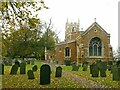
Church of St Mary, Harby
View from the east. 14th century Decorated east window. Listed Grade II*.
Image: © Alan Murray-Rust
Taken: 19 Oct 2020
0.17 miles
10
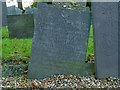
Belvoir Angel headstone, Harby Churchyard
To Katherine, wife of John Hand, d.1719.
Image: © Alan Murray-Rust
Taken: 23 Oct 2016
0.17 miles