IMAGES TAKEN NEAR TO
Nether Street, MELTON MOWBRAY, LE14 4BT
Introduction
This page details the photographs taken nearby to Nether Street, LE14 4BT by members of the Geograph project.
The Geograph project started in 2005 with the aim of publishing, organising and preserving representative images for every square kilometre of Great Britain, Ireland and the Isle of Man.

There are currently over 7.5m images from over14,400 individuals and you can help contribute to the project by visiting https://www.geograph.org.uk
Image Map
Images are licensed for reuse under creativecommons.org/licenses/by-sa/2.0
Notes
- Clicking on the map will re-center to the selected point.
- The higher the marker number, the further away the image location is from the centre of the postcode.
Image Listing (80 Images Found)
Images are licensed for reuse under creativecommons.org/licenses/by-sa/2.0
Image
Details
Distance
1
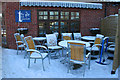
Any one for tea?
All that's missing is the parasol!
The Tea Junction, a small café attached to the village garage and shop in Harby.
Image: © Kate Jewell
Taken: 8 Jan 2010
0.03 miles
2
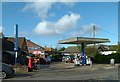
Proud Purveyors of Petrol, Pizza, Pumpkins and Postal services
Harby Garage is nothing if not versatile in its range of services, having taken on the role of village shop and Post Office in recent years.
Image: © Alan Murray-Rust
Taken: 23 Oct 2016
0.03 miles
3
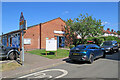
Harby Village Hall, School Lane
A model-railway event was taking place inside, on a fine Sunday afternoon in August.
Image: © John Sutton
Taken: 11 Aug 2024
0.06 miles
5
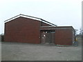
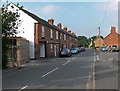
Harby Telephone Exchange, Leics
This modern red-brick TE is located at 2 Langar Lane, North of the village and near the disused Grantham Canal. Its postcode is LE14 4BL.
Image: © David Hillas
Taken: 8 Mar 2010
0.08 miles

7
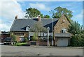
The Nag's Head, Harby
This is believed to date back to the 15th century, altered in the first half of the 17th century, and the right hand wing added in 1722 http://www.geograph.org.uk/photo/5169054 . Listed Grade II*.
Image: © Alan Murray-Rust
Taken: 23 Oct 2016
0.10 miles
8

Datestone, The Nag's Head, Harby
On the gable end of the cross wing. See http://www.geograph.org.uk/photo/5169053 for location.
Image: © Alan Murray-Rust
Taken: 23 Oct 2016
0.10 miles
9
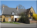
Harby Nags Head
20 Main Street. Half timbered and ironstone Grade II listed building.
Image: © the bitterman
Taken: 17 Apr 2010
0.10 miles
10
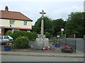
Harby War Memorial
A grade II listed building, the War Memorial was erected in 1920 to honour those who died in World War I.
Image: © JThomas
Taken: 27 Jul 2013
0.11 miles