IMAGES TAKEN NEAR TO
Church Lane, MELTON MOWBRAY, LE14 4AE
Introduction
This page details the photographs taken nearby to Church Lane, LE14 4AE by members of the Geograph project.
The Geograph project started in 2005 with the aim of publishing, organising and preserving representative images for every square kilometre of Great Britain, Ireland and the Isle of Man.

There are currently over 7.5m images from over14,400 individuals and you can help contribute to the project by visiting https://www.geograph.org.uk
Image Map
Images are licensed for reuse under creativecommons.org/licenses/by-sa/2.0
Notes
- Clicking on the map will re-center to the selected point.
- The higher the marker number, the further away the image location is from the centre of the postcode.
Image Listing (82 Images Found)
Images are licensed for reuse under creativecommons.org/licenses/by-sa/2.0
Image
Details
Distance
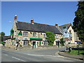
2
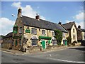
The Marquis of Granby Public House, Waltham on the Wolds
Image: © Bill Henderson
Taken: 25 Jul 2012
0.01 miles
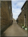
3
Church Lane, Waltham on the Wolds
This narrow little lane leads off northwards from the High Street opposite the church.
Image: © Kate Jewell
Taken: 13 May 2008
0.03 miles
4
The Marquis of Granby, Waltham on the Wolds
Image: © JThomas
Taken: 26 May 2012
0.04 miles
5
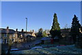
Looking down to Melton Road (A607), Waltham on the Wolds
From the churchyard of St Mary Magdalene
Image: © Tim Heaton
Taken: 23 Jan 2019
0.04 miles
6

Waltham on the Wolds War Memorial.
Waltham on the Wolds War Memorial, Leicestershire.
Image: © gary radford
Taken: 4 Oct 2009
0.05 miles
7
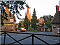
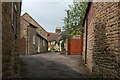
Cross roads in the centre of Waltham
The A607 runs through the centre of this village. Two pubs and the large church of St Mary Magdalene are on this busy cross roads where it meets Main Street and Goadby Lane.
Image: © Kate Jewell
Taken: 3 Aug 2005
0.05 miles
8
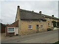
Thatched Farm, Waltham on the Wolds
Eighteenth century former farmhouse https://historicengland.org.uk/listing/the-list/list-entry/1294569
Image: © Jonathan Thacker
Taken: 2 Apr 2021
0.05 miles
9
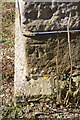
Benchmark on St Mary Magdalene's Church
Ordnance Survey cut mark benchmark described on the Bench Mark Database at http://www.bench-marks.org.uk/bm47838
Image: © Roger Templeman
Taken: 2 Apr 2013
0.05 miles