IMAGES TAKEN NEAR TO
Bescaby Lane, MELTON MOWBRAY, LE14 4AB
Introduction
This page details the photographs taken nearby to Bescaby Lane, LE14 4AB by members of the Geograph project.
The Geograph project started in 2005 with the aim of publishing, organising and preserving representative images for every square kilometre of Great Britain, Ireland and the Isle of Man.

There are currently over 7.5m images from over14,400 individuals and you can help contribute to the project by visiting https://www.geograph.org.uk
Image Map
Images are licensed for reuse under creativecommons.org/licenses/by-sa/2.0
Notes
- Clicking on the map will re-center to the selected point.
- The higher the marker number, the further away the image location is from the centre of the postcode.
Image Listing (27 Images Found)
Images are licensed for reuse under creativecommons.org/licenses/by-sa/2.0
Image
Details
Distance
1
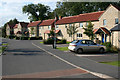
Twells Road, Waltham on the Wolds
New cottage style housing on the eastern edge of the village.
Image: © Kate Jewell
Taken: 8 Oct 2008
0.01 miles
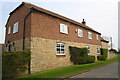
2
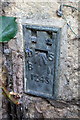
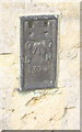
Benchmark on #1 Bescaby Lane
Ordnance Survey flush bracket benchmark with serial number 1243 described on the Bench Mark Database at http://www.bench-marks.org.uk/bm1983
Image: © Roger Templeman
Taken: 20 Apr 2014
0.02 miles
3
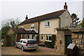
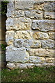
'High Cairn', #1 Bescaby Lane
There is an OS flush bracket benchmark Image at the junction of the two parts of the house, between the black downpipe and a rosebush
Image: © Roger Templeman
Taken: 20 Apr 2014
0.02 miles
4
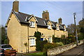
Cottages on the north side of High Street
The black OS flush bracket benchmark Image can be seen on the front of the near cottage at its near corner
Image: © Roger Templeman
Taken: 20 Apr 2014
0.04 miles
5
Benchmark on #49 High Street
Ordnance Survey flush bracket (serial number 1390) benchmark described on the Bench Mark Database at http://www.bench-marks.org.uk/bm1969
Image: © Roger Templeman
Taken: 20 Apr 2014
0.05 miles
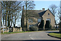
6
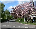
Bescaby Lane in Waltham on the Wolds
At the junction with the High Street.
Image: © Mat Fascione
Taken: 15 May 2010
0.06 miles
7
Bescaby Lane leading off the High Street, Waltham On The Wolds
Image: © Tim Heaton
Taken: 29 Jun 2017
0.08 miles
8
Benchmark on 'The Granary'
Ordnance Survey cut mark benchmark described on the Bench Mark Database at http://www.bench-marks.org.uk/bm56801
Image: © Roger Templeman
Taken: 20 Apr 2014
0.09 miles
9
'The Granary', a former farm building
There is an OS benchmark Image on the front of the house at the near corner
Image: © Roger Templeman
Taken: 20 Apr 2014
0.09 miles
10
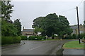
The Mount, Waltham on the Wolds
A large limestone house at the eastern end of Main Street.
Image: © Kate Jewell
Taken: 17 Feb 2008
0.10 miles