IMAGES TAKEN NEAR TO
Mill Lane, MELTON MOWBRAY, LE14 3SF
Introduction
This page details the photographs taken nearby to Mill Lane, LE14 3SF by members of the Geograph project.
The Geograph project started in 2005 with the aim of publishing, organising and preserving representative images for every square kilometre of Great Britain, Ireland and the Isle of Man.

There are currently over 7.5m images from over14,400 individuals and you can help contribute to the project by visiting https://www.geograph.org.uk
Image Map
Images are licensed for reuse under creativecommons.org/licenses/by-sa/2.0
Notes
- Clicking on the map will re-center to the selected point.
- The higher the marker number, the further away the image location is from the centre of the postcode.
Image Listing (56 Images Found)
Images are licensed for reuse under creativecommons.org/licenses/by-sa/2.0
Image
Details
Distance
1
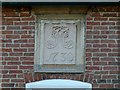
Datestone, 159 Main Street Asfordby
A stylish example with a florid 'M' monogram. See http://www.geograph.org.uk/photo/5208704 for location.
Image: © Alan Murray-Rust
Taken: 25 Nov 2016
0.04 miles
2

159 Main Street Asfordby
Former farmhouse, dated 1730 http://www.geograph.org.uk/photo/5208706 , the exterior being largely unspoilt. Brickwork in Flemish garden wall bond, on a high ironstone plinth with Swithland slate roof, Listed Grade II.
Image: © Alan Murray-Rust
Taken: 25 Nov 2016
0.04 miles
3

The former Blue Bell Inn, Asfordby
Now converted to residential use. The building includes 17th century timber framing but was refaced in the 19th century. Listed Grade II.
Image: © Alan Murray-Rust
Taken: 25 Nov 2016
0.05 miles
5
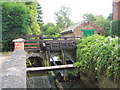
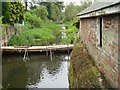
Footpath over old sluice gate, Asfordby
The footpath entering Asfordby from the south crosses over old sluice workings which regulated flow in the nearby former canal.
Image: © Tim Heaton
Taken: 12 Aug 2007
0.07 miles
6

Former Methodist chapel, Asfordby
Now converted to residential use.
Image: © Alan Murray-Rust
Taken: 25 Nov 2016
0.09 miles
7
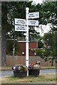
Old Direction Sign - Signpost by Main Street, Asfordby
Ball finial - 4 arms; Leics. simple ball by the UC road, in parish of Asfordby (Melton District), junction of Station Lane with Main Street, on grass triangle with flower planters.
Surveyed
Milestone Society National ID: LE_SK7018
Image: © Milestone Society
Taken: Unknown
0.09 miles
9
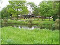
The old millstream
Looking downstream from the footbridge over the millstream channel
Image: © Jim Thornton
Taken: 14 May 2006
0.11 miles
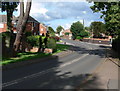
10
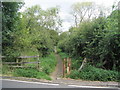
Footpath to Asfordby
The footpaths from neighbouring villages of Kirby Bellars and Frisby enter Asfordby from Station Road
Image: © Tim Heaton
Taken: 12 Aug 2007
0.11 miles